How to Use AI and NLP to Search Quebec’s SIGEOM Database for Lithium in The Examine Reports
Discover how to leverage AI and NLP to search Quebec's SIGÉOM database for lithium in The Examine reports. Uncover hidden mineral deposits and streamline your exploration process with advanced technology. Learn more in our latest blog!


SIGÉOM (Système d’information géominière)
SIGÉOM is a unique spatial reference geomining information system managed by the Gouvernement du Québec. It contains an extensive geoscientific database collected over the past 150 years. This database includes geological mapping surveys, prospection, and exploration activities conducted by the Ministry, mining companies, and universities.
Key features include:
- Interactive Map: Provides a global overview of the SIGÉOM database.
- Data and Web Services: Offers access to geophysical products and allows for data download by themes or NTS-sheet number.
- Examine Documents: A gateway to the Géologie Québec record holdings, with over 80,000 documents including bibliographic data, reports, and maps.
The EXAMINE tool within Québec’s SIGÉOM (Système d’information géominière) is a valuable resource for accessing a vast collection of geoscientific documents, including over 80,000 items such as bibliographic data, reports, and maps. While the EXAMINE platform allows for basic keyword searches, it falls short in replicating the nuanced reading, understanding, and analysis that geoscientists and explorers require to identify potential leads and opportunities from these historical datasets. RadiXplore offers an alternative to Québec SIGÉOM’s EXAMINE platform, providing enhanced capabilities for this purpose.
What is RadiXplore and How Does It Mimic Geological Thinking When Analyzing Legacy, Poor-Quality Scanned, and Handwritten Reports?
Using our Hybrid Extractive Search module, we can efficiently search through approximately 4.7 million pages of documents to identify the geological signatures of hard rock lithium deposits, such as pegmatites associated with minerals like spodumene, petalite, lepidolite, zinnwaldite, and amblygonite. The "Hybrid Extractive Search" approach, as detailed in our linked article, accounts for various representations of words and phrases, including spelling variations and mistakes, ensuring comprehensive search results. Let's start the search and walk through the process step-by-step.
Step 1 - Plot SIGÉOM's Mineral Potential WMS Layer on RadiXplore's Map Display to Focus on Unexplored Areas
The mineral potential layer from Québec’s SIGÉOM (Système d’information géominière) is a specialized dataset that highlights regions with high potential for mineral deposits. This layer is based on an integration of geological, geophysical, and geochemical data to pinpoint areas most likely to contain valuable mineral resources. By plotting this layer on RadiXplore's map display, we can strategically avoid well-known mineralized zones and concentrate exploration efforts on less mapped areas, optimizing the discovery process.
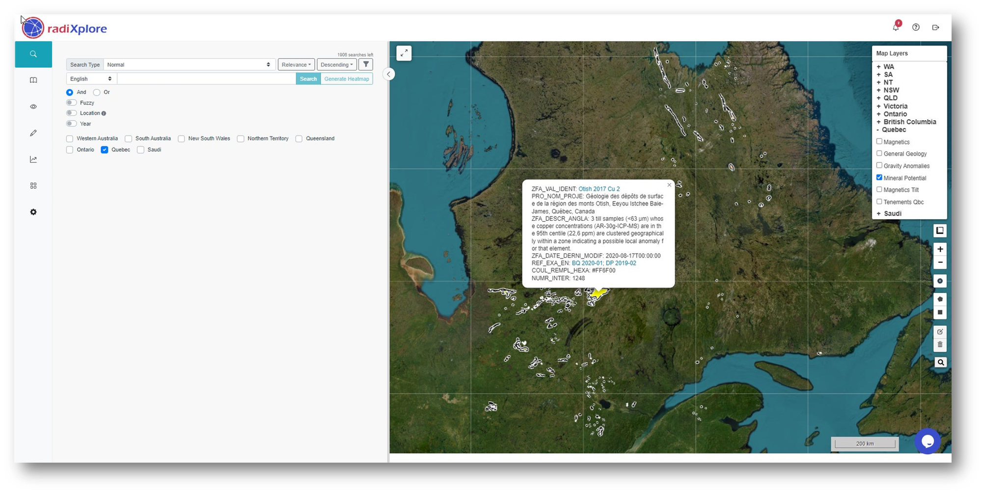
Mineral potential studies traditionally rely almost entirely on structured datasets, with unstructured datasets rarely utilized. When they are used, it is often just a small fraction of the information, manually extracted through labor-intensive reading. RadiXplore aims to change this by breathing new life into unstructured, text-rich datasets, making it possible for anyone to explore and navigate these vast resources with ease.
Step 2 - Use Nerd Search to Mimic Geological Thinking and Analyze French Text Patterns for Hard Rock Analogues
We utilize the Nerd Search feature to emulate geological reasoning by searching for text patterns indicative of our hard rock lithium analogue. To broaden our search scope, we'll switch the language to French, enabling GeoAI to analyze French documents within the data repository.
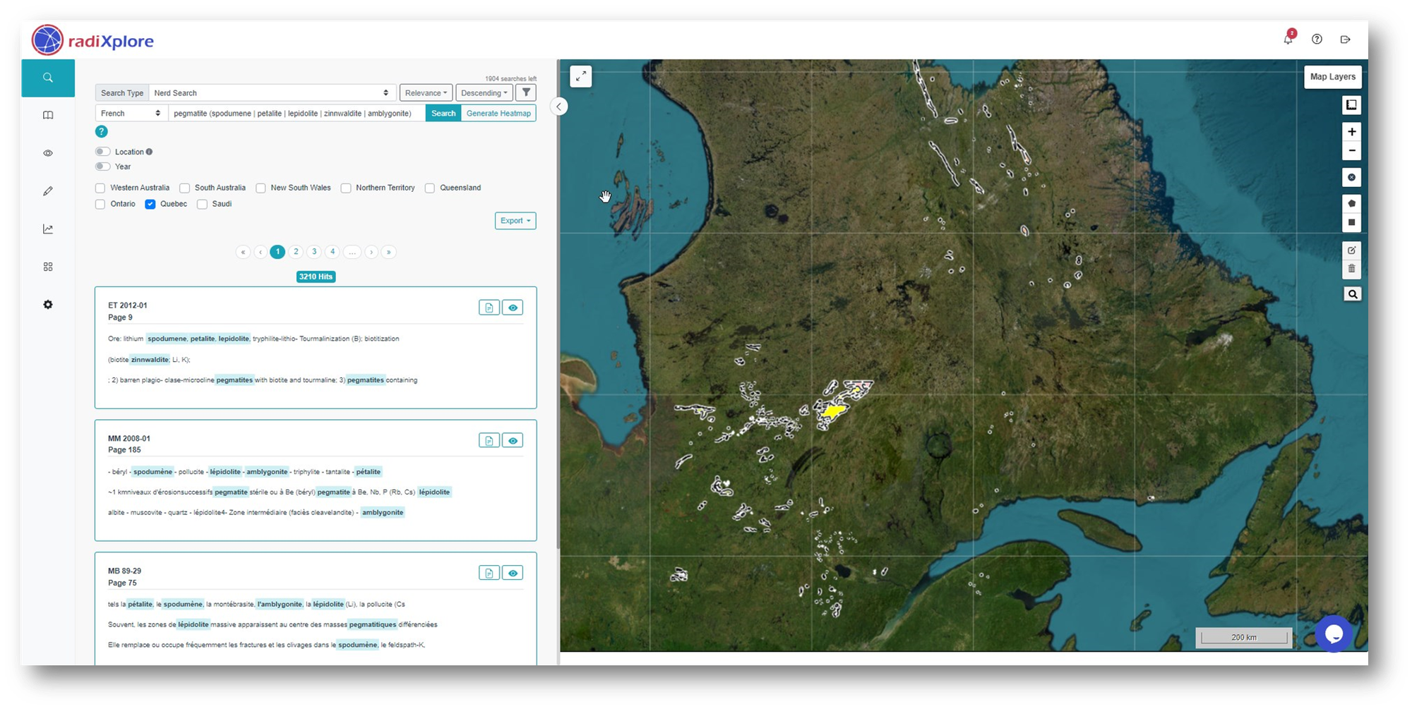
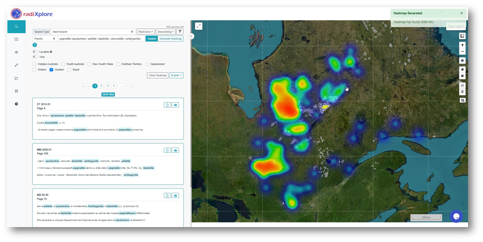
With over 3,210 relevant results identified, we can visualize these findings geospatially by creating a heatmap that correlates them with their historical tenement locations. This approach allows us to uncover potential exploration targets efficiently.
By selecting hit number 2, which corresponds to page 75 in report MM 2008-01, we can instantly view the associated historical tenement on the map, along with its detailed metadata.

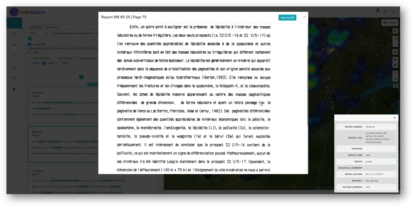
Step 3 - Open the Report to the Relevant Page for In-Depth Review
RadiXplore allows you to jump directly to the specific page where the result was found, enabling you to read and assess the context. This gives you the opportunity to verify whether the result is accurate or a false positive.
Let's translate this so its easier to understand for non french speakers.
Step 4 - Understading and Intepreting the answer
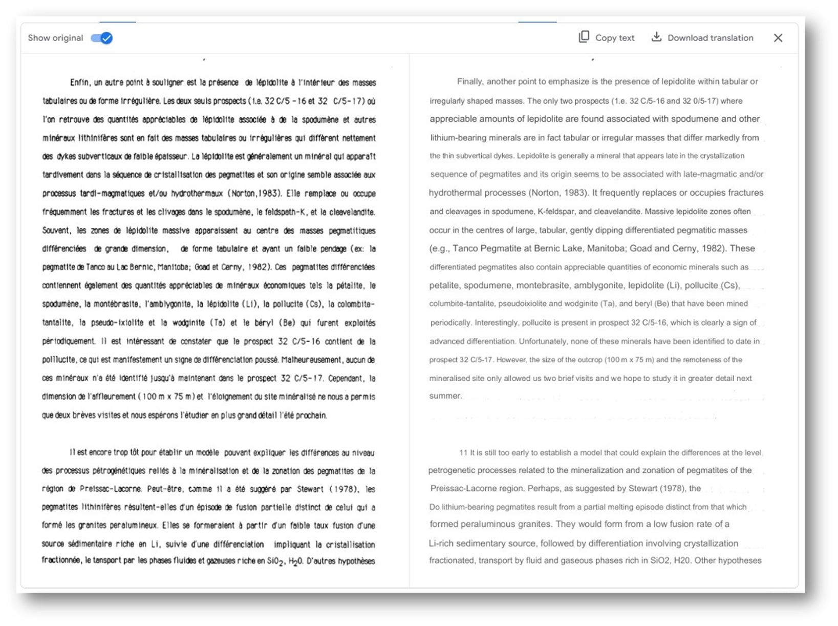
Based on this text, the authors did find evidence of lithium mineralization in the form of lepidolite associated with spodumene and other lithium-bearing minerals. The presence of lepidolite, particularly in tabular or irregular masses, is a strong indicator of lithium mineralization in pegmatites.
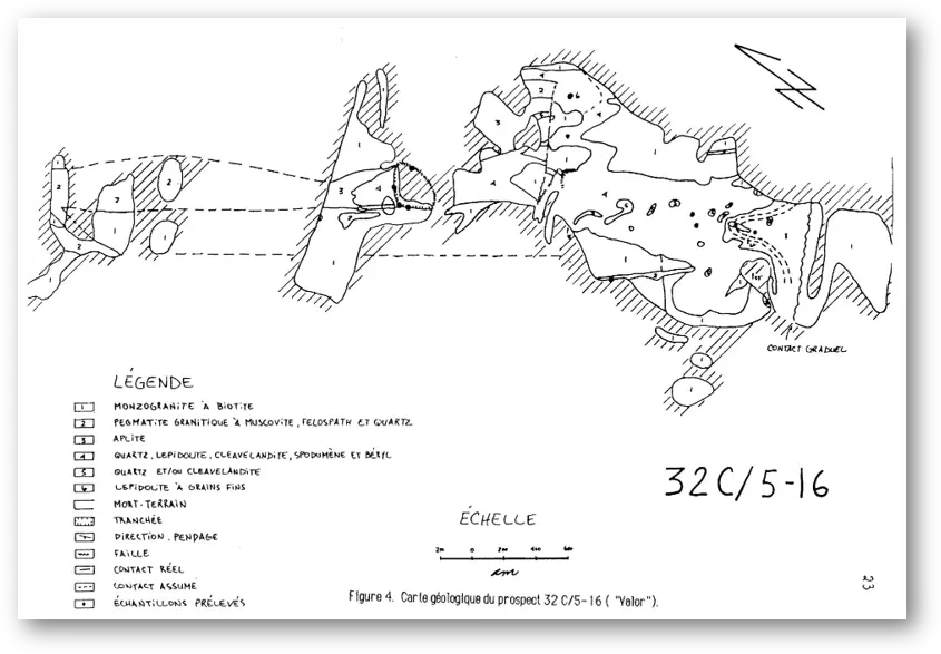
The authors also mention the presence of pollucite in prospect 32 C/5-16, which is another sign of advanced differentiation and potential for lithium mineralization. While they did not identify pollucite in prospect 32 C/5-17, they hope to study it in more detail in the future.
Why is the presence of lepidolite is a strong indicator of lithium mineralization in pegmatites?
- Lithium-rich composition: Lepidolite is a mica mineral that contains significant amounts of lithium. Its formation is often associated with lithium-rich environments.
- Association with other lithium minerals: Lepidolite is frequently found in association with other lithium-bearing minerals, such as spodumene, petalite, and amblygonite. This co-occurrence suggests a common source of lithium in the pegmatite.
- Formation conditions: Lepidolite often forms in the late stages of pegmatite crystallization, indicating a high degree of differentiation and concentration of lithium in the remaining magma or hydrothermal fluids.
- Tabular or irregular masses: The occurrence of lepidolite in tabular or irregular masses is particularly significant, as it suggests that these masses have undergone more advanced differentiation and concentration of lithium than the surrounding pegmatite. This is often associated with the presence of economic-grade lithium mineralization.
What is the significance of Pollucite here?
Pollucite is a cesium-rich mineral that is often found in pegmatites. Its presence in prospect 32 C/5-16 is significant for several reasons:
- Indicator of advanced differentiation: Pollucite typically forms in the late stages of pegmatite crystallization, indicating that the pegmatite has undergone significant differentiation. This means that the minerals in the pegmatite have become more concentrated and specialized.
- Association with other valuable minerals: Pollucite is often associated with other valuable minerals, such as lithium-bearing minerals (like spodumene and lepidolite) and tantalum-niobium minerals. This suggests that the pegmatite may also contain other economically important elements.
- Potential for cesium production: Pollucite is a major source of cesium, a rare earth metal with various industrial applications. Its presence in the pegmatite could indicate a potential resource for cesium production.
Therefore, the presence of pollucite in prospect 32 C/5-16 is a positive sign for the potential economic value of the pegmatite, as it suggests advanced differentiation, association with other valuable minerals, and the possibility of cesium production.
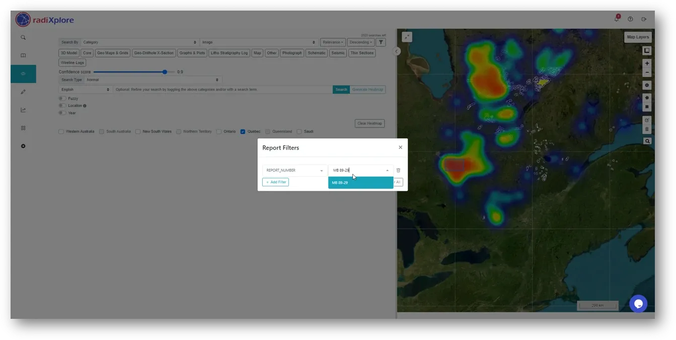
Step 5 - Using RadixEye to browse through images and tables in report MB 89-29 to find something relevant
We can begin by applying a report filter to focus on analyzing only the report of interest.
Performing a search displays all the images within this document. Similarly, you can select tables to view all tables in the document and even extract them to Excel using RadixExtract!
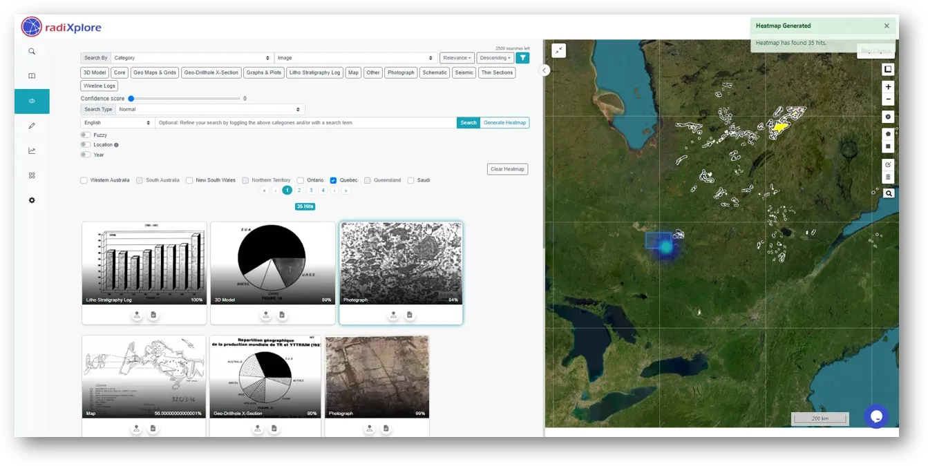
We need to pinpoint the exact locations of the prospects, which are likely shown on a map. Instead of browsing through 35 images to find a map, we can simply select the "map" filter to quickly display only the images that are maps.
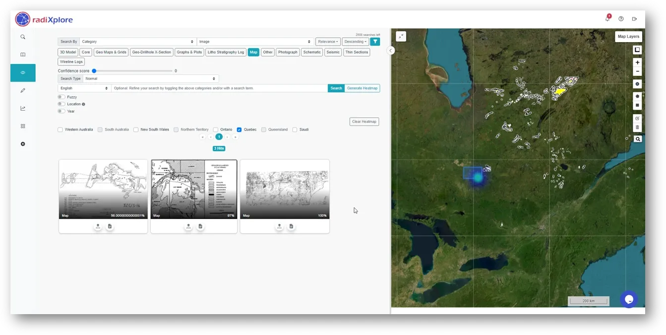
Opening the first map, we find our answer: a hand-drawn geological map for the prospect, which includes pollucite.
The next step is to georeference this map. Unfortunately, I don’t believe this process can be fully automated by AI.
While AI and automated tools like RadiXplore can significantly enhance mineral exploration, they do have limitations that require further investigation. This might involve additional analysis by companies or field validation to confirm the findings. Even if a particular lead doesn’t pan out, RadiXplore’s initial search might reveal a cluster of other valuable leads waiting to be explored.
RadiXplore equips you with the tools to leverage your expertise and navigate unstructured datasets effectively—whether they are open-file records from major mining jurisdictions or proprietary datasets languishing in cloud storage. The possibilities are endless.
Ready to explore these possibilities? Try RadiXplore for free by signing up on our website, or contact us for a personalized demo to see how our technology can transform your exploration, project generatoin and data review workflows.