Unearthing India's Mineral Wealth: A Deep Dive into NGDR Data From Maharashtra
Explore Maharashtra's rich mineral wealth with NGDR data analysis, interactive maps, and dashboards. Discover key commodities, exploration trends, and the future potential of AI platforms like RadiXplore in Indian mining.

Maharashtra, a state renowned for its diverse and complex geology, holds a wealth of significant mineral resources, absolutely vital for bolstering India's industrial framework and sustained economic growth. The recent, and highly commendable, availability of comprehensive mining and exploration data through the National Geoscience Data Repository (NGDR) portal represents a paradigm shift. It offers an unprecedented, democratized opportunity to meticulously analyze, comprehensively understand, and strategically unlock this vast untapped potential.
Previously, such detailed information might have been fragmented or less accessible, but the NGDR is a true game-changer. As a geoscience data analyst with decades of experience navigating global mining datasets, I've had the privilege of delving into the NGDR's offerings for Maharashtra, and the insights emerging are profoundly compelling. This analytical journey, further illuminated by the power of visualizing project areas, permit boundaries, and crucial overlaps using dynamic tools, paints an increasingly clear and actionable picture of the state's rich mineral landscape and signals an exciting, data-driven future for mineral exploration across India.
Maharashtra's Mineral Cornucopia: What the Data Reveals
The NGDR data for Maharashtra is nothing short of a digital treasure trove. It meticulously catalogs a vast array of exploration projects, details specific commodity types, and archives invaluable geological findings accumulated over decades. My analysis of this rich dataset, which included an initial sample of over 260 distinct projects, immediately highlights a vibrant and diverse tapestry of mineral occurrences, painting a picture of significant geological wealth.
Key Commodities Driving Exploration:
The data reveals a strong and sustained focus on a variety of minerals, each playing a critical role in different sectors. The most frequently explored commodities, indicating areas of high interest and potential, include:
- Base Metals: Consistently leading the exploration efforts with 34 recorded projects, these metals (like copper, lead, and zinc) are fundamental to construction, manufacturing, and electrical industries.
- Manganese: A critical industrial mineral, particularly for steel production and battery manufacturing, with 31 projects noted. Its presence is vital for strengthening alloys and as a key component in modern energy solutions.
- Gold: The ever-precious metal, a universal store of value and an important component in electronics, shows 28 distinct exploration instances, reflecting its enduring allure and economic significance.
- Iron Ore: The backbone of industrialization and fundamental to infrastructure development, with 24 projects, highlighting its strategic importance for national growth.
- Copper & Bauxite: Both are crucial for a multitude of industries – copper for its conductivity in electrical applications and bauxite as the primary ore for aluminum production. They account for 22 and 21 projects respectively.
- Tungsten: Another strategic mineral, prized for its hardness and high melting point, making it essential for high-performance alloys and industrial tools, with 20 projects.
Beyond these front-runners, the dataset also compellingly points to significant exploration for Diamond (with its obvious value in jewelry and industrial abrasives), Limestone (essential for cement and construction), Coal (a primary energy source), Platinum Group Elements (PGE) (critical for catalytic converters and advanced electronics), Rare Metals, Nickel (key for stainless steel and batteries), and Rare Earth Elements (REEs) (indispensable for modern technologies like magnets, batteries, and defense applications), among many others.
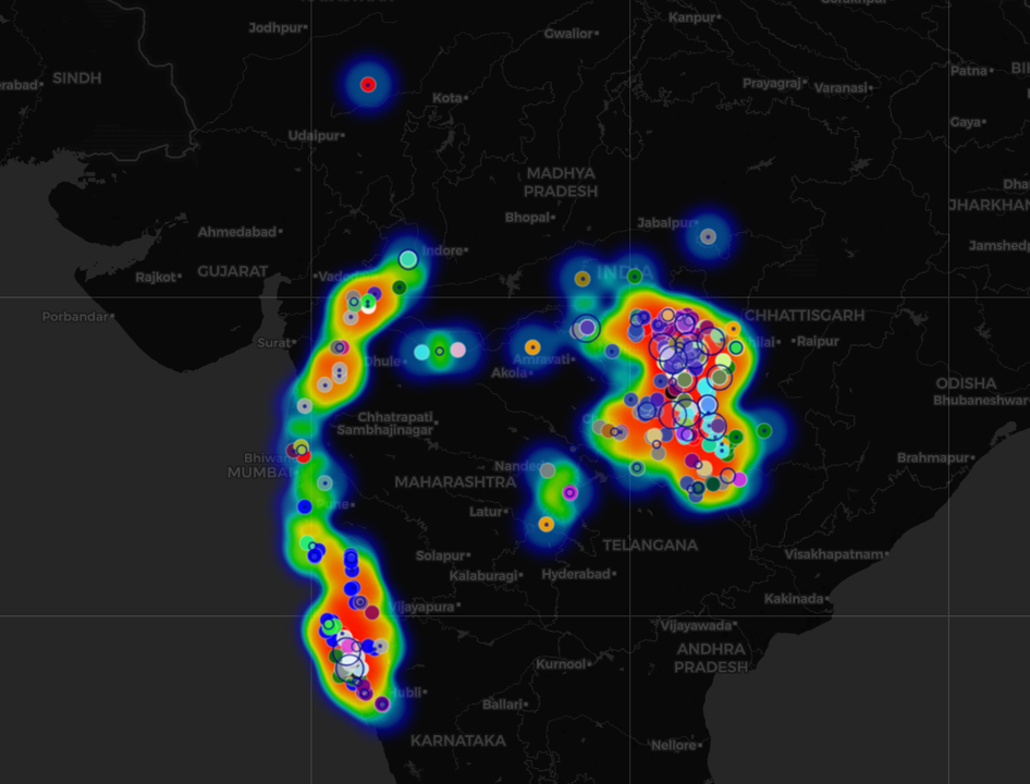
To bring this data to life, we've embedded an interactive map just below. This map offers a dynamic, visual exploration of the trends discussed above:
- Toggleable Commodity Layers let you explore where different minerals are being investigated, with color-coded polygons representing project boundaries.
- Project Markers provide quick access to specific site information, complete with commodity-specific icons and detailed popups.
- A Heatmap of Exploration Intensity helps you quickly identify exploration hotspots—areas where activity is most concentrated.
- And finally, District-Level Circles reveal the number of projects and highlight top commodities within each region.
This interactive tool enables you to dive deeper into the spatial distribution of exploration activity, spot emerging patterns, and better understand which minerals are attracting the most attention—and where.
This remarkable diversity powerfully underscores Maharashtra's complex and favorable geological framework. It clearly signals the state's immense potential to contribute a wide and strategically important array of raw materials necessary for India's self-reliance and technological advancement.
A Century of Exploration: Tracking Maharashtra's Mining Journey
The NGDR data provides an invaluable historical lens, allowing us to track the evolution of exploration activities across Maharashtra. The meticulously maintained records show projects dating as far back as 1922, painting a picture of sustained, albeit fluctuating, interest in the state's mineral wealth, culminating in a cumulative count of over 269 projects by 2023.
This long and storied history of exploration, primarily spearheaded by pioneering organizations like the Geological Survey of India (GSI), has been instrumental. The GSI, through its systematic mapping and resource assessment programs, has built a foundational and increasingly sophisticated understanding of the state's diverse mineral systems and geological provinces. These early efforts, even those that didn't immediately lead to commercial mining, have created an irreplaceable legacy of geological knowledge that continues to inform and guide modern exploration strategies.
Phases of Discovery: Exploration Stages
The data categorizes projects by their exploration stage, offering crucial insights into the maturity of various prospects and the overall exploration pipeline:
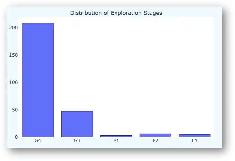
- G4 (Reconnaissance): This is the most common stage encountered in the dataset, with the clear majority of projects falling under this category (e.g., Base Metals: 27 projects, Manganese: 27 projects, Gold: 20 projects). G4 involves broad-level geological mapping, regional geochemical sampling, and initial geophysical surveys to identify large areas of potential mineral interest with relatively lower initial investment.
- G3 (Preliminary Exploration): Several commodities, such as Bauxite (9 projects) and Base Metals (7 projects), have advanced to this stage. G3 exploration involves more detailed surface mapping, trenching, and limited drilling to better define anomalies identified in G4 and to gain a preliminary understanding of the ore body's geometry and grade.
- E1 (Regional Exploration) & P2 (Detailed Prospecting): A smaller, yet significant, number of projects, particularly for high-value commodities like Copper and Gold, have advanced to these more intensive and costly stages. E1 might involve systematic grid drilling and more comprehensive geophysical surveys, while P2 focuses on detailed drilling to delineate a resource, signifying higher confidence in the mineral presence and potential economic viability.
Interestingly, the timeline of exploration activity, particularly at the G4 reconnaissance stage, shows distinct peaks in various years. For instance, there was a notable surge in projects initiated in the early 1960s and 1970s, likely driven by post-independence industrialization efforts and a national push for resource self-sufficiency. More recently, a resurgence in activity is evident (2022-2023 showing 7 and 9 G4 projects respectively), potentially reflecting new geological models, advancements in exploration technologies making previously challenging terrains accessible, and shifting global demand for critical minerals.
These trends underscore how exploration is dynamically influenced by evolving geological understanding, breakthroughs in technological capabilities, and overarching economic drivers.
The Digital Delve: Understanding the NGDR Data Structure
The true, transformative power of the NGDR lies not just in the volume of data it hosts, but in the richness, variety, and increasing interconnectedness of that information. My analysis of the file structures and associated metadata reveals a comprehensive and well-organized collection, designed to support diverse analytical needs:
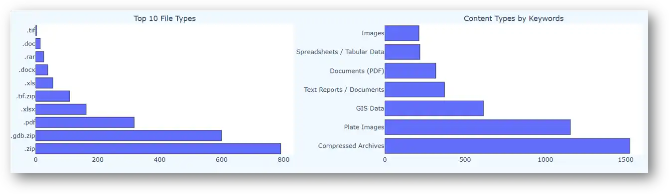
- Geospatial Gold: A very significant portion of the data comprises crucial GIS datasets (over 615 instances, often conveniently packaged in
.gdb.zipformat) and highly detailed georeferenced images (such as.tiffiles, frequently found within.ziparchives, totaling over an impressive 1150 plate images). This geospatial information is invaluable for precise spatial analysis, accurate tenement mapping, drillhole planning, and the development of 3D resource models. - Textual Treasures: An extensive collection of detailed reports and documents (over 370, primarily in accessible
.pdfand editable.docxformats) provide crucial geological context, describe exploration methodologies, detail analytical results, and present the interpretations and conclusions from past exploration campaigns. These narratives are essential for understanding the 'why' and 'how' behind the data points. - Tabular Truths: A wealth of spreadsheets and tabular data (around 219 files, commonly in
.xlsxor.xlsformats) offer structured, quantifiable information. This includes critical data like chemical assay results from rock or soil samples, detailed borehole logs (lithology, alteration, mineralization), and other numerical metrics vital for statistical analysis and resource estimation. - Visual Vistas: General images (often
.jpgfiles, sometimes compiled within.ziparchives) can include illustrative site photographs, images of geological formations, core photos showing mineralization, and other visual documentation that adds another layer of understanding to the field observations.
The prevalence of compressed archives (like .zip and .rar) indicates that a vast amount of detailed information is being efficiently managed and made accessible through the portal. Furthermore, the logical organization into common directories such as GEOREF_IMAGES, GIS_FILES, TEXT, TABLES, and IMAGE provides a clear and intuitive structure, greatly assisting users in navigating this wealth of information and locating the specific data they need for their analyses.
The ability to access these diverse data types from a single, integrated platform is a significant step forward for geoscience research and mineral exploration in India.
Visualizing Opportunities: The Impact of Geospatial Insights & Interactive Tools
Static data tables and lengthy reports, while foundational, often require significant effort to discern underlying patterns and spatial relationships. As demonstrated by the initial commodity map visualizing project areas, plotting this data geospatially is key. However, taking this a step further with interactive tools dramatically enhances user engagement and understanding.
Bringing Maharashtra's Mineral Landscape to Life:
Here is an interactive dashboard providing a comprehensive, at-a-glance overview of the key analytics derived from the NGDR data overlapping Maharashtra, including commodity frequencies, exploration stage distributions, and temporal trends.
Maharashtra Exploration Dashboard
View interactive visualizations of exploration activity across key commodities and regions in Maharashtra.
 🔍 Open Dashboard Fullscreen
These tools empower users—from researchers and potential investors to policymakers and the general public—to directly interrogate the data, customize their views, and derive their own insights. Such interactive visualizations allow for:
- Strategic Regional Planning
- Infrastructure Development
- Environmental Management
- Investment Attraction
The AI-Powered Frontier: Unleashing NGDR Data with Advanced Analytics
The digitization and centralization of geoscience data through initiatives like the NGDR mark a critical inflection point for the industry. These repositories don’t just store information—they hold latent insights waiting to be unlocked. With tens of thousands of geospatial layers, scanned field notes, historic reports, maps, and tabular datasets, the real challenge lies not in access, but in interpretation at scale.
This is where Artificial Intelligence (AI) becomes transformative. By replicating how expert geologists think—linking mineral systems, inferring context from ambiguous reports, and spotting subtle patterns—AI can turn static archives into dynamic exploration tools.
Enter RadiXplore: a platform purpose-built to do exactly that. RadiXplore uses AI to analyze the messy, unstructured backbone of geological knowledge—open file reports, hand-annotated maps, legacy PDFs, drill logs, and more. It doesn't just skim documents; it understands them geologically. What once required months of expert review can now be done in hours—with the ability to search, cluster, and visualize historical data in ways previously impossible.
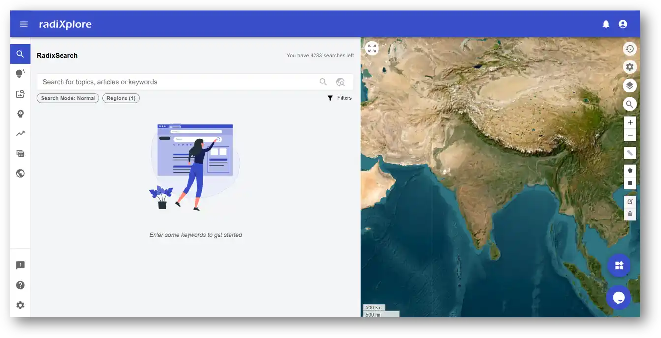
RadiXplore is not a general AI tool repurposed for geology. It’s a domain-specific intelligence layer, designed to help explorers surface forgotten prospects, validate ground quickly, and generate new targets from data that’s been overlooked for decades.
How can such AI platforms supercharge the NGDR data for exploration companies?
- Deep Dive into Unstructured Data: The NGDR contains hundreds of textual reports and legacy documents. RadiXplore, using Natural Language Processing (NLP), deep learning, and large language models, can rapidly sift through these documents. It doesn't just perform keyword searches; it understands geological context, extracts key features, mineralization indicators, and exploration outcomes, converting invaluable unstructured information into actionable, structured insights for companies.
- Uncovering Hidden Connections: By processing diverse NGDR datasets holistically – correlating geological maps with remote sensing data, seismic surveys with borehole logs, and geochemical assays with textual descriptions – AI can identify subtle anomalies and complex patterns that might be missed by human interpreters or conventional software. This can lead to the identification of previously unrecognized mineral deposits or new interpretations of known areas, directly benefiting a company's exploration strategy.
- Accelerating Discovery Cycles: With the NGDR providing the foundational data, AI platforms can dramatically reduce the time for companies to move from initial area assessment to identifying high-potential drill targets. This means exploration timelines are shortened, and associated costs can be significantly reduced.
- De-risking Exploration Ventures: By enabling a more comprehensive and rapid analysis of all available NGDR data for a region, AI provides a more robust understanding of the geology and mineral potential. This allows companies to make more informed decisions and invest capital with higher confidence, focusing efforts on the most promising targets.
- Maximizing Existing Assets: For companies holding their own extensive proprietary archives alongside utilizing public NGDR data, platforms like RadiXplore can be deployed privately. This allows them to transform their internal data from static storage into dynamic strategic assets, finding new connections and insights by integrating it with the broader geological context provided by NGDR.
The application of such AI-powered analysis to the NGDR dataset can lead to a multitude of transformative outcomes:
- Predictive Targeting
- Automated Data Synthesis and Advanced Interpretation
- Enhanced Resource Estimation
- Smart Monitoring and Anomaly Detection
- Optimized Exploration Workflows
Feeding Maharashtra's detailed NGDR data, and eventually the comprehensive pan-India dataset, into such geology-focused AI platforms will undoubtedly revolutionize the exploration landscape. It will accelerate the pace of discovery, significantly improve exploration success rates, and contribute to more sustainable and efficient resource development across the nation. This synergy between rich public datasets and intelligent analytical tools signals a new era for unearthing India's mineral wealth.
Maharashtra's Mining Future & The Pan-India Potential
The NGDR data for Maharashtra is far more than just a static historical archive; it's a dynamic launchpad for future discoveries, innovation, and sustainable mineral development. The insights gleaned—from identifying specific commodity hotspots like the Bhandara, Nagpur, and Chandrapur regions for base metals and chromite, to a deeper understanding of the exploration lifecycle and success factors—can directly guide future investment decisions, inform evidence-based policy formulation, and stimulate targeted academic and applied research. This historical data can be invaluable in training modern machine learning models to predict new prospective areas.
What's truly exciting is that this transformative initiative extends well beyond the borders of Maharashtra. The NGDR is progressively consolidating similar invaluable geoscience data from across the entire Indian subcontinent. This national repository holds the immense potential to:
- Democratize Access: Providing transparent, standardized, and readily available data.
- Spur Innovation: Enabling advanced data analytics, ML, and AI for faster discoveries.
- Attract Investment: Enhancing India's attractiveness for global mining investment.
- Support Sustainable Mining: Allowing for better long-term planning and environmental stewardship.
The ongoing journey of analyzing Maharashtra's NGDR data is a powerful testament to the profound impact of open and accessible geoscience information. It empowers stakeholders at all levels to look beneath the surface, to better understand our rich geological heritage, and to responsibly and efficiently harness the resources that will undoubtedly fuel India's future growth and development.
The potential locked within these rapidly expanding digital archives, for Maharashtra and for the entirety of India, is truly immense and is eagerly waiting to be fully unearthed and intelligently utilized.
Ready to Discover More?
See how RadiXplore can help you unlock insights from historical exploration data and accelerate project generation.
📧 Contact Us to Book a Demo