Unlocking British Columbia's ARIS Reports: RadiXplore's New AI Tool for Discovering Porphyry Copper Deposits
RadiXplore is excited to announce the integration of British Columbia ARIS reports into our platform. This addition empowers geologists to efficiently identify mineral deposits by leveraging AI-driven searches and advanced data analytics. Discover how RadiXplore transforms mineral exploration today!

ARIS (Assessment Report Indexing System) is a database maintained by the British Columbia Geological Survey (BCGS) that contains technical assessment reports related to mineral exploration and development activities within the province. These reports are filed by the exploration and mining industry and provide valuable information on geological, geophysical, geochemical, drilling, and other exploration-related activities.
Key Points about ARIS Reports:
- Comprehensive Coverage: ARIS includes a vast collection of assessment reports dating back to 1947, offering a rich historical perspective on mineral exploration in British Columbia.
- Detailed Information: The reports provide in-depth details about exploration work, including methodologies, results, and conclusions.
- Public Access: Once a report reaches a certain age (typically one year from the date of registration), it becomes publicly available and can be accessed through the ARIS database.
- Search Functionality: The ARIS database allows users to search for reports based on various criteria, such as location, mineral type, or report number.
- Map-Based Visualization: Many ARIS reports can be viewed on a map, providing a visual representation of exploration activities and mineral occurrences.
Limitations of the ARIS Search System
While ARIS excels at hosting British Columbia’s relinquishment reports and providing basic keyword search capabilities on text and metadata, it struggles to offer a seamless integration of this vast information into the workflows of mining companies. Extracting actionable insights from these reports still requires a manual process—reading, understanding, and identifying key data points.
To understand the scale of this challenge, let’s examine some key statistics:
- Total number of pages: 2,927,811
- Images embedded within reports: 168,068
- Tables embedded within reports: 346,620
These images include various types—maps, geological diagrams, cross-sections, and more—critical for interpreting mineralization and exploration results. The embedded images can be categorized as follows:
Each image is embedded within dense PDF reports and is often unsearchable using conventional methods, even if basic OCR (Optical Character Recognition) is applied. Image analysis is essential for understanding the spatial distribution of minerals, geological formations, and historical drill results.
Given these numbers and complexities, the limitations of the ARIS search system become clear. Exploration geologists often seek to identify unrecognized mineral deposits or missed geological patterns that earlier exploration efforts may have overlooked. With the current ARIS system’s basic keyword search, it becomes nearly impossible to uncover these insights efficiently. The result is that critical information remains buried within this vast and underutilized repository, leaving geologists and mining companies at a disadvantage.
In the next section, we’ll explore how RadiXplore leverages AI to simulate the nuanced ways geologists sift through such datasets, revolutionizing how mining companies analyze ARIS data and enabling them to uncover hidden mineral potential more effectively.
What is RadiXplore, and How Does it Solve These Challenges?
RadiXplore is an advanced AI platform designed to emulate the analytical work of a geologist, specifically focused on mining exploration data. Instead of requiring companies to manually search for, download, clean, and process vast datasets—a process that can take months before meaningful analysis can even begin—RadiXplore offers a streamlined, AI-driven alternative.
Mining companies can simply sign up through our website, select their area of interest, and specify the type of mineral deposit they are looking for. RadiXplore does the rest.
Our platform employs deep learning to analyze and interpret embedded images, such as geological maps and cross-sections, within historical reports. Through natural language processing (NLP), RadiXplore comprehends and extracts key insights from the text, understanding complex geological terms and identifying relevant data. In addition, RadiXplore leverages advanced language models to mimic a geologist’s decision-making process, simulating the nuanced analytical approaches needed to recognize missed deposits, geological trends, or mineralization patterns.
One of RadiXplore’s standout features is its ability to integrate GIS (geographic information system) data, enabling users to visualize potential mineral deposits and exploration targets on a map. This is all achieved within hours, not weeks or months.
RadiXplore offers two key solutions:
- Info-as-a-Service (Info-aaS): Providing access to a curated database of high-quality mining data, including historic reports and new discoveries.
- Software-as-a-Service (SaaS): Allowing companies to upload and analyze their own proprietary data using RadiXplore’s powerful AI engine.
With RadiXplore, mining companies can significantly accelerate their exploration efforts, reduce the burden of manual labor, and make data-driven decisions with greater confidence. Our innovative AI solution reshapes how companies approach mineral exploration, unlocking new opportunities for discovery and resource evaluation.
How a Geologist Uses RadiXplore to Find Porphyry Copper Deposits from ARIS Reports in British Columbia
RadiXplore offers geologists advanced tools to search for minerals, host rocks, alterations, and assays using hybrid keyword search techniques. However, its true power lies in its unique predictive modeling capabilities for analyzing unstructured text data from reports.
While traditional models focus on structured datasets like geophysics and geochemistry, RadiXplore goes further by applying Natural Language Processing (NLP) and machine learning to vast unstructured datasets. It can automatically analyze geological observations and core descriptions from millions of pages, uncovering patterns that suggest undiscovered deposits, such as porphyry copper. This enables geologists to generate mineral prospectivity maps and pinpoint promising areas quickly.
RadiXplore revolutionizes this process by turning previously overlooked text-rich data into valuable insights, helping geologists make faster, more informed exploration decisions.
How Can We Describe a Porphyry Copper Deposit to RadiXplore? What is Its Text Signature?

Porphyry copper deposits have distinct geological and mineralogical characteristics that can be identified through textual descriptions in reports. Here are the key indicators:
- Rock Types and Textures: Look for descriptions of mafic to felsic intrusive rocks with porphyritic textures. Common rock types include diorite, quartz diorite, and granite.
- Mineralogy: Key minerals to identify include copper-bearing minerals such as chalcopyrite, bornite, and molybdenite, along with pyrite, magnetite, and biotite.
- Alteration: Porphyry deposits often show potassic, propylitic, or argillic alteration. Potassic alteration is marked by biotite and potassium feldspar, while propylitic alteration features chlorite, epidote, and sericite, and argillic alteration includes clay minerals like kaolinite and smectite.
- Geochemical Signatures: High concentrations of copper, molybdenum, and gold are typical, along with elevated levels of sulfur, iron, and potassium.
- Structural Features: Descriptions of faults, fractures, and breccia zones often signal the localization of mineralization within porphyry systems.
RadiXplore’s AI can identify these key text signatures, enabling geologists to quickly locate potential porphyry copper deposits with greater precision.
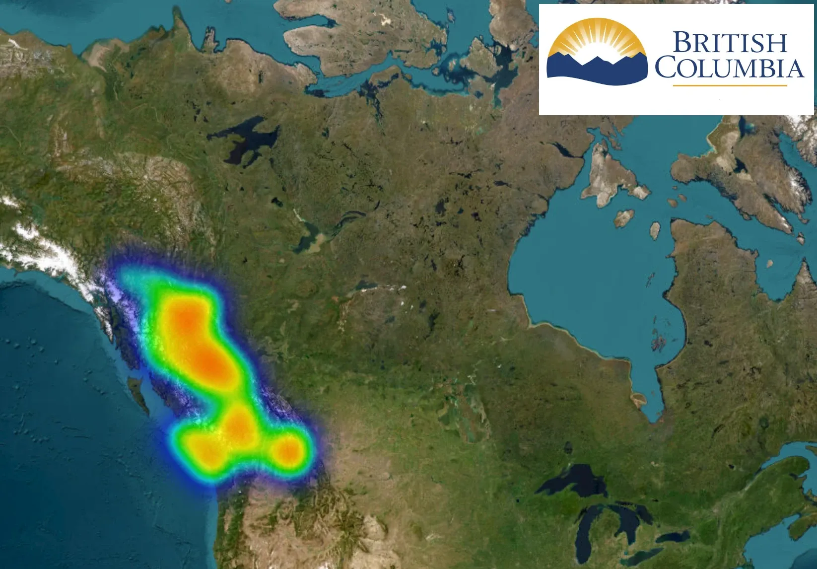
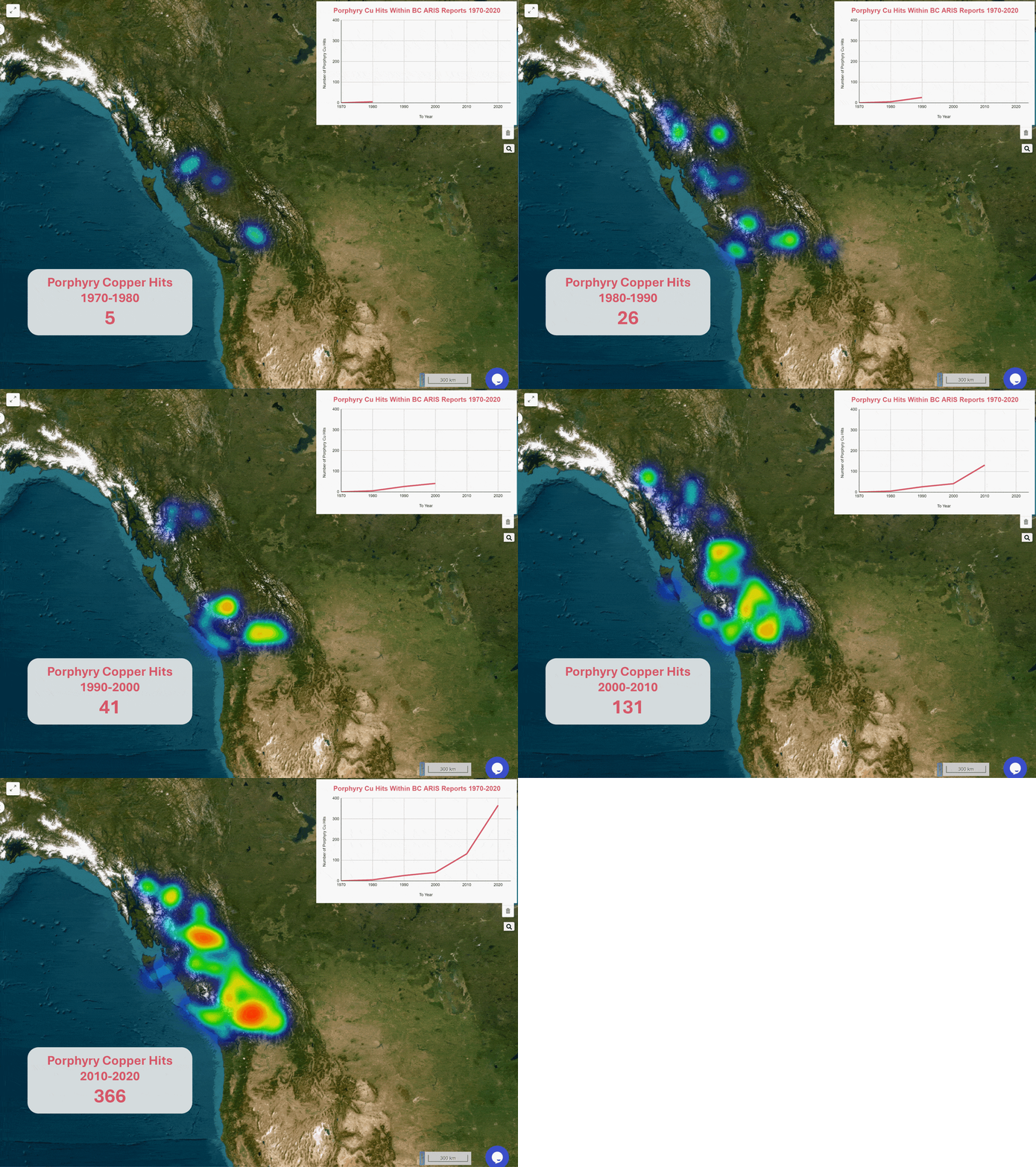
While we’ll dive deeper into how to use NerdSearch to pinpoint geological analogues in a later blog post, let’s first explore the results. We searched for this porphyry copper signature within the ARIS relinquishment reports and grouped the findings by decade. Using heatmaps, we visualized the geospatial distribution of hits over time, from 1970 to 2020.
This provides a powerful overview of where significant copper mineralization indicators have been detected over the years, offering new insights for exploration planning.

The data indicates a clear upward trend in the identification of porphyry copper deposits, particularly in the last two decades. This increasing trend not only reflects greater exploration activity but also underscores the potential for new discoveries in British Columbia, driven by advancements in geological modeling and data analysis.
Conclusion
The increasing identification of porphyry copper deposits in British Columbia, as demonstrated by the analysis of ARIS reports, highlights the evolving landscape of mineral exploration. With the advancements in AI technology, such as those offered by RadiXplore, geologists can efficiently analyze vast datasets and uncover valuable insights that were previously challenging to access.
If you're ready to enhance your exploration efforts and unlock the potential of untapped mineral resources, we invite you to experience the capabilities of RadiXplore firsthand. Sign up on our website today to explore our innovative AI platform and discover how you can accelerate your mineral exploration efforts.
Whether you're looking to utilize our curated Info-aaS database or analyze your own data through our SaaS platform, RadiXplore is here to support your journey toward discovery.
Join us in reshaping the future of mining exploration and uncovering new opportunities!

