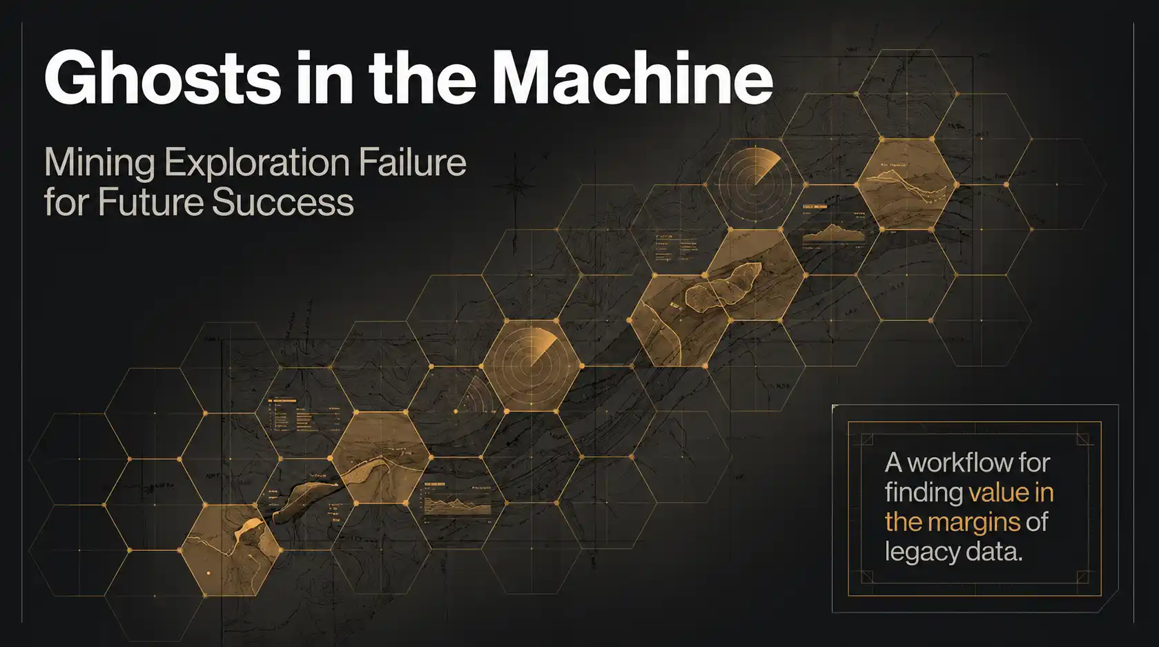
Ghosts in the Machine: AI Mapping Uranium Near-Misses in the Athabasca Basin
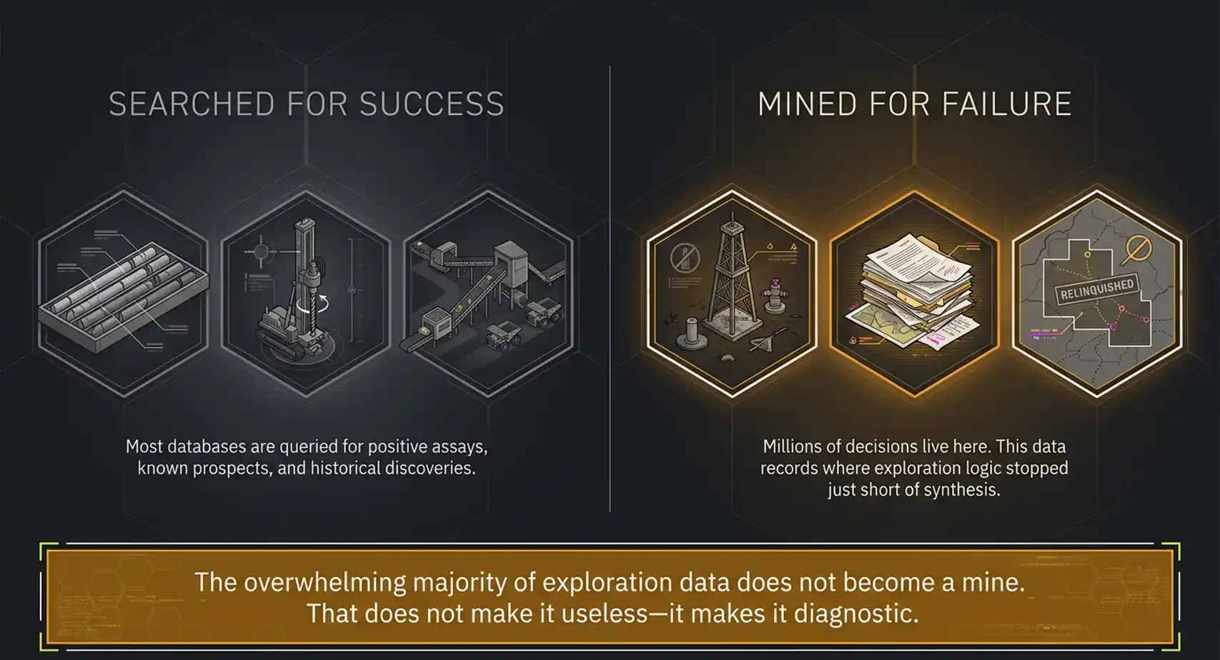
Most exploration archives are searched for success. We searched for failure: the abandoned conductors, negative drill holes, unresolved alteration halos, and historical decisions that may point to the next generation of discoveries.

Most exploration archives are searched for success: discoveries, assays, deposits, mines, and known prospects. But the deeper opportunity often sits in the opposite category: failure.
Every abandoned drill program, inconclusive geophysical survey, negative report, relinquished project, and forgotten anomaly contains a decision. Someone tested a geological idea, interpreted the evidence available at the time, and chose whether to continue or walk away.
That decision may have been correct. Or it may have been constrained by the commodity price, the depth of the target, the technology available, the deposit model of the day, the budget cycle, the boardroom, or simply the inability to synthesize thousands of scattered observations into one coherent geological story.
That is the premise behind Ghosts in the Machine: a workflow for finding value in exploration failure.
Instead of treating historical reports as static documents, we treat them as evidence of geological reasoning: what was tested, what was missed, why work stopped, and whether that conclusion still holds under modern geological, economic, and technical conditions.
In our earlier work on Saudi Arabia's legacy geological archives, we argued that national exploration databases are not just inventories. They are memory systems. They preserve the edges of old thinking: the places where exploration logic stopped just short of synthesis.
This Athabasca Basin case study takes that idea one step further. We applied the Ghosts in the Machine workflow to historical uranium exploration records and converted old, dusty archives of unstructured reports into basin-scale hexagon maps designed to answer one question:
Where did historical uranium exploration come close, and why did it stop?
To answer that, we combined failure analysis with mineral systems thinking. The workflow did not simply ask where exploration failed. It asked where historical work stopped despite evidence for the ingredients of a uranium system: source, pathway, trap, alteration, and unresolved follow-up.
This is not a story about replacing geologists. It is a story about giving geologists a hawk's-eye view across millions of pages of legacy text, so they can rapidly identify smaller areas of interest where deeper technical review is worth the time.
The Problem: Most Exploration Data Records Failure
The mining industry spends billions of dollars every year generating exploration data. The overwhelming majority of that work does not become a mine.
That does not make the data useless. It makes it diagnostic.
Most historical assessment reports were written to document work completed: lines flown, holes drilled, samples collected, anomalies followed up, and recommendations made. But when read at scale, they also document something more valuable:
- the geological models people believed at the time
- the tools and detection limits available to them
- the commodities they cared about
- the assumptions that shaped their interpretation
- the moment where the project was advanced, paused, downgraded, or abandoned
Historical reports contain not only observations. They contain decisions.
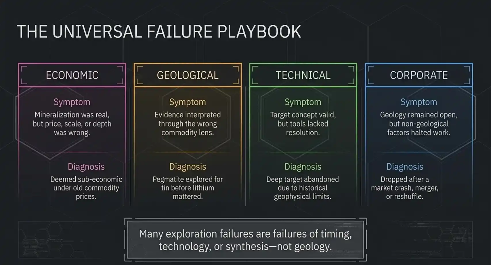
That distinction matters because many exploration "failures" are not pure geological failures. Some are failures of timing. Some are failures of technology. Some are failures of interpretation. Some are failures of synthesis.
The archive remembers all of them. But only if it can be read as a system.
The Universal Failure Playbook
The Ghosts in the Machine workflow starts from a simple idea:
Exploration failure has patterns.
The geological details change from commodity to commodity, but the structure of failure is often surprisingly consistent. We classify historical exploration outcomes into four broad failure types.
Economic failure
The mineralization may have been real, but the price, scale, depth, infrastructure, or cost structure was wrong at the time.
Geological failure
The evidence was interpreted through the wrong model or the wrong commodity lens.
Technical failure
The target concept was valid, but the tools were not good enough: depth penetration, geophysics, drilling, assaying, metallurgy, or modelling.
Corporate failure
The geology remained open, but the company stopped for non-geological reasons: funding, ownership, market cycles, merger activity, or portfolio logic.
This is the Universal Failure Playbook. It is universal because it can be applied across regions and commodities. But it only becomes useful when paired with a commodity-specific lens.
For gold, the failure mode might be shallow oxide drilling that never tested the primary system at depth. For lithium, it might be historical pegmatite work where explorers logged the right rocks but never assayed for lithium because they were chasing tin or tantalum. For copper and nickel, it might be conductive systems dismissed as barren sulphides, even though the geochemical vectoring was incomplete.
For uranium in the Athabasca Basin, the near-miss signature is different again.
Why The Athabasca Basin Is A Perfect Near-Miss Test
The Athabasca Basin is one of the world's most important uranium provinces. It is also one of the best places to test a near-miss workflow, because the exploration problem is subtle.
High-grade unconformity uranium systems can be blind, deep, structurally controlled, and spatially small relative to their alteration footprints. A single drill hole can miss the mineralized pod but still pass through important halo evidence. A conductor can be necessary but not sufficient. A negative assay can still be a valuable geological vector.
Historical reports may contain electromagnetic conductors that were never fully drilled, graphitic or pelitic basement rocks interpreted as traps, faulting or basement architecture that could provide pathways, bleached sandstone or clay alteration, and uranium or radiometric evidence that was never fully resolved.
Individually, any one of these observations may be ambiguous. Together, they can describe an unfinished uranium system.
The Athabasca Near-Miss Hypothesis
For this study, we focused on two main near-miss classes.
1. The Untested Conductor
An electromagnetic survey identifies a strong basement conductor, often interpreted as graphitic or structurally controlled.
The conductor may be deep, difficult, expensive, poorly resolved, or drilled only partially. Historical reports may recommend follow-up work, but the record does not show a clear resolution.
This is a classic trap identified, test incomplete scenario.
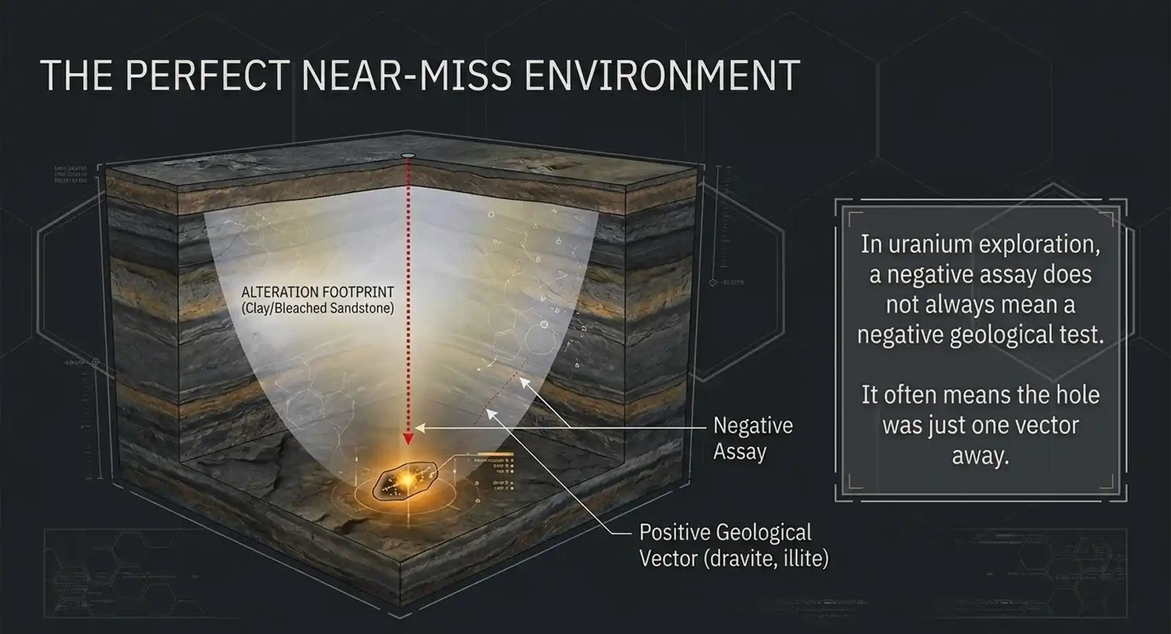
2. The Alteration Halo
A drill hole misses the uranium mineralization but intersects the hydrothermal footprint around it.
The report may describe bleached sandstone, clay alteration, dravite, illite, sudoite, chlorite, hematization, graphitic basement, pelitic units, shearing, or faulting. The assay result may be negative, but the geological information is not.
This is a classic system found, ore position missed scenario.
In uranium exploration, a negative assay does not always mean a negative geological test. It may mean the hole was one vector away.
From Dusty Reports To Hexagon Maps
The dataset behind this work is not a clean, modern database of drill collars and assays. It is the kind of material most exploration teams know too well: historical assessment files, scanned reports, narrative summaries, geophysical interpretations, drill logs, lab appendices, recommendations, relinquishment-era notes, and map references written by different companies across different cycles.
In normal workflows, this material is read manually: one report at a time, one area at a time, one geologist at a time.
That is exactly why so much value stays buried.
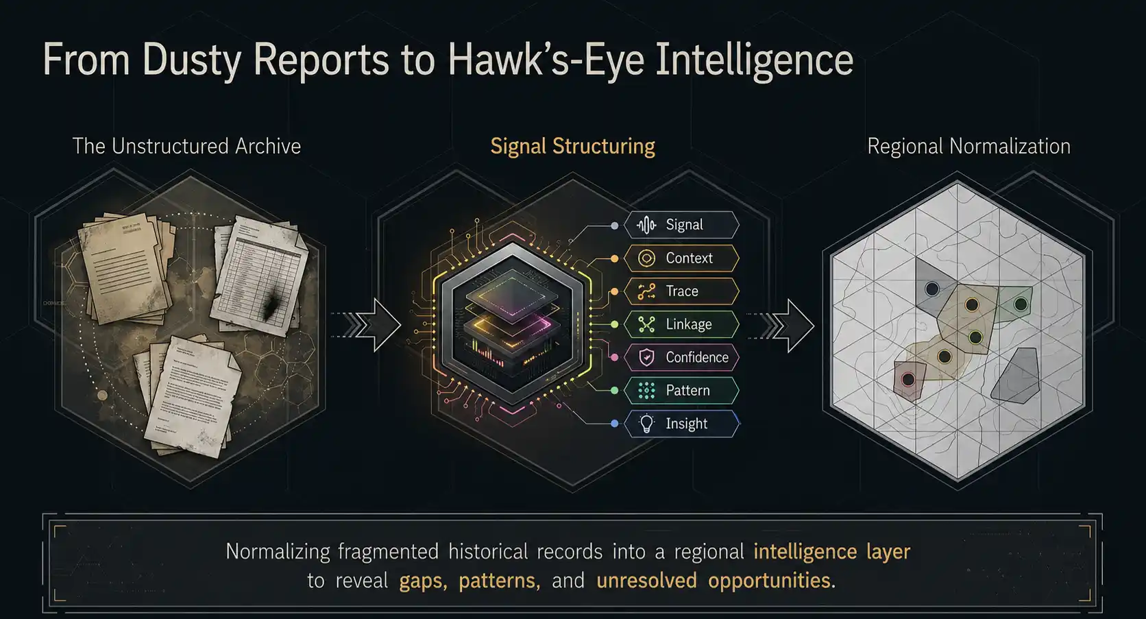
For this study, we used AI to , and whether the historical conclusion looked resolved or unresolved.
We then normalized that evidence into regional hexagon cells. The purpose was not to pretend that every historical record has drill-collar precision. Much of the historical data is polygonal, report-scale, survey-scale, or project-scale. The hexagon approach creates a consistent regional framework for comparing evidence, effort, and follow-up intensity.
The output is not a final drill plan. It is a hawk's-eye targeting layer.
It points to smaller areas of interest where a technical team can justify the next stage: report retrieval, drill validation, plate georeferencing, land-status review, geophysical reprocessing, and detailed geological interpretation.
Map 1: Untested Conductors
The first map asked a simple question:
Where did historical explorers do a lot of electromagnetic targeting, but comparatively little diamond drilling?
For Athabasca uranium, that is a meaningful discrepancy. A mature, high-confidence conductor target should eventually attract drilling. If the archive shows repeated EM work, conductor interpretation, and follow-up recommendations but limited evidence of drill resolution, the system may be flagging an orphaned target.
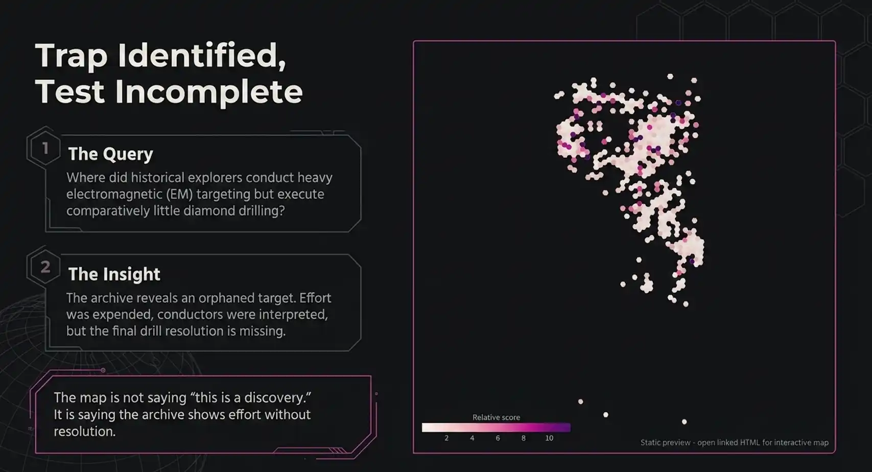
This map behaved in two important ways.
First, it did not simply light up every area with EM data. Mature areas with substantial drilling were moderated because the historical record suggests that those targets were tested more heavily.
Second, it highlighted discrete cells where the amount of geophysical attention appeared high relative to the apparent drill testing.
For a geologist, those are not automatic targets. They are questions worth asking:
- Was the conductor ever drilled?
- Was the drill hole actually on the current axis?
- Was the target too deep for the budget at the time?
- Did later work resolve the anomaly, or did the project simply stop?
- Would modern EM inversion, resistivity, gravity, or directional drilling change the interpretation?
The map is not saying "this is a discovery." It is saying "the archive shows effort without resolution."
Map 2: Alteration Near-Misses
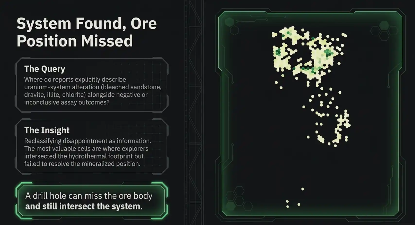
The second map looked for a different discrepancy:
Where did historical reports describe uranium-system alteration, but the reported outcome was negative, neutral, or inconclusive?
Exploration archives are full of negative reports. But negative reports often contain positive geological information.
In the Athabasca Basin, a drill hole can miss the ore body and still intersect bleached sandstone, clay alteration, chlorite, illite, dravite, sudoite, hematization, graphitic or pelitic basement, faulted basement, anomalous radioactivity, or hydrothermal alteration.
Those observations may not have been enough to justify continued spending at the time. But under a modern mineral systems lens, they can be vectoring evidence.
This map therefore did something that conventional report search rarely does:
It reclassified disappointment as information.
The most interesting cells were not necessarily the ones with the strongest uranium results. They were cells where the text suggested that explorers had intersected parts of the system but failed to resolve the mineralized position.
For a technical team, the next questions become:
- Did the hole test the right structure?
- Was the alteration proximal or distal?
- Was the target model correct?
- Were the clay minerals properly understood at the time?
- Was the follow-up abandoned because the geology failed, or because the program failed?
That is the difference between reading reports and diagnosing near-misses.
Map 3: Uranium Ghost Evidence
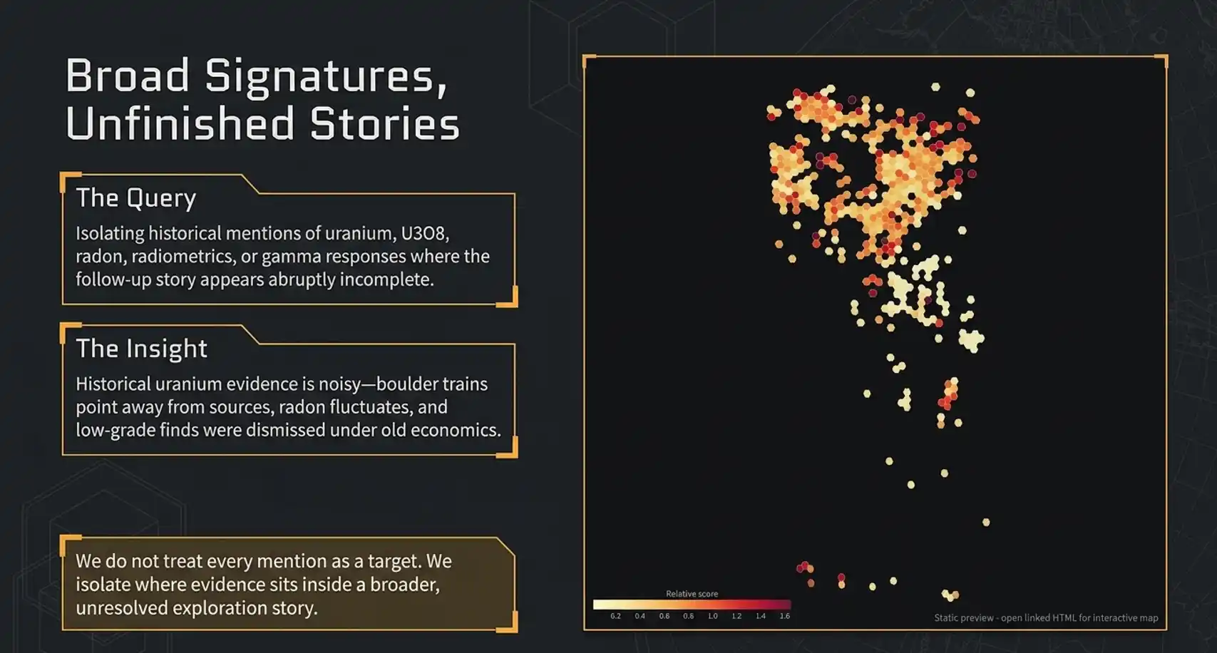
The third map isolated uranium-focused evidence. It looked for historical records containing uranium, U3O8, radioactivity, radiometrics, radon, scintillometer work, gamma response, uranium minerals, or related language where the follow-up story appeared incomplete.
This is the broadest of the near-miss maps. It captures the areas where the archive says uranium evidence was present, the source may not have been resolved, the scale may not have been understood, or the historical conclusion may deserve a modern second pass.
This layer is especially useful because historical uranium evidence is not always straightforward. Surface radioactivity can be transported. Boulder trains can point away from the source. Radiometric anomalies can be surficial, structural, or lithological. Radon can be noisy. Low-grade uranium can be dismissed under one economic regime and become meaningful under another.
The value of this map is not that it treats every uranium mention as a target. It identifies where uranium evidence sits inside a broader unresolved exploration story.
Mineral Systems Thinking: The Geological Filter
Near-miss targeting becomes much more powerful when it is combined with mineral systems thinking.
For Athabasca unconformity uranium, the question is not simply: is there a conductor? Is there alteration? Was uranium mentioned?
The better question is:
Do the historical reports describe the ingredients of a complete uranium system?
For this study, we organized the evidence into four broad mineral system components.
Source
Uranium, radioactivity, uranium minerals, radiometrics, radon, gamma response, or uranium-bearing samples.
Pathway
Faults, shears, breccias, fractures, lineaments, structural corridors, or unconformity architecture.
Trap
Graphite, graphitic units, pelites, pyrite, reductants, basement highs, or chemically favourable basement rocks.
Outflow
Bleaching, illite, dravite, chlorite, sudoite, kaolinite, desilicification, clay alteration, or hydrothermal alteration.
Single features can mislead. A conductor is not a target by itself. Alteration is not a target by itself. Uranium anomalism is not a target by itself.
The opportunity appears when these features begin to form a coherent system.
Map 4: Mineral System Fertility
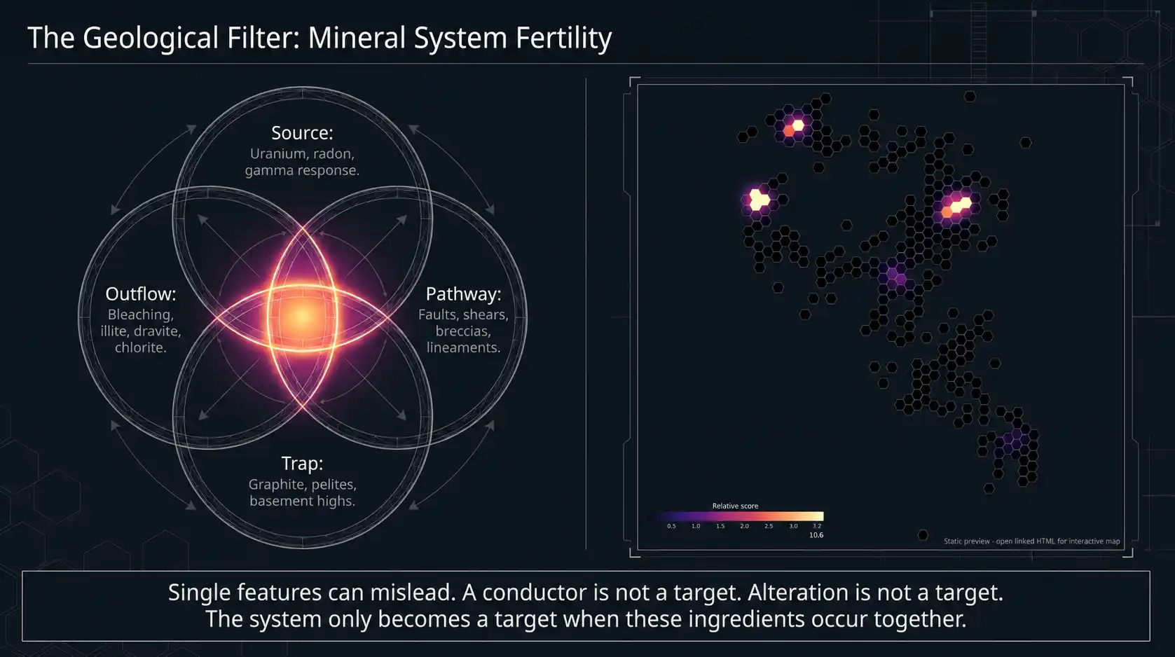
The mineral system fertility map asked:
Where do source, pathway, trap, and outflow evidence occur together in the historical record?
This map is the geological counterweight to the near-miss maps. The near-miss layers identify unresolved historical situations. The mineral system layer asks whether those unresolved situations are geologically meaningful.
That distinction is critical.
An untested conductor in the wrong geological context may be noise. A negative drill hole with weak alteration may be noise. A uranium mention without structure may be noise.
But when conductors, alteration, uranium evidence, structures, traps, and hydrothermal language begin to overlap, the story changes.
This map helped separate areas with lots of paperwork from areas with meaningful geological convergence.
For regional targeting, that is the point. The goal is not to read every report immediately. The goal is to decide where deeper reading is justified.
Integration: The Confluence Engine
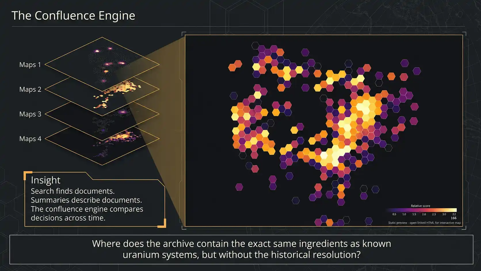
The final step was integration. We combined the near-miss maps with the mineral system fertility map to create a master confluence layer.
The strongest cells were those where multiple independent lines of evidence overlapped:
- under-tested conductor opportunity
- alteration near-miss evidence
- uranium ghost evidence
- mineral system fertility
This is where the workflow becomes more than search.
Search finds documents. Summaries describe documents. The confluence engine compares decisions across time.
It asks:
Where does the archive contain the same ingredients as known uranium systems, but without the same level of historical resolution?
That is the real target-generation question.
The First Test: Did It Find What Geologists Already Know?
The first test of any targeting workflow is not whether it finds something new. It is whether it can rediscover what is already known, without being told where to look.
In this study, the confluence engine passed that test.
Several of the highest-ranking cells corresponded to known Athabasca uranium systems: historic production districts, modern high-grade discoveries, active exploration camps, and advanced uranium corridors.
That mattered.
It showed that the model was not simply ranking areas with more reports. It was recognizing the combination of evidence that geologists already associate with real uranium systems: conductors, structure, alteration, uranium evidence, basement traps, and repeated follow-up intensity.
This is an important validation step. If the engine cannot light up known systems, there is no reason to trust it when it lights up unknown ones.
But once the known systems appear where they should, the more interesting question becomes:
What else has the same signature?
The More Interesting Result: The Ghost Targets
After treating known systems as calibration points, the next step was to look for cells with similar confluence signatures but different historical outcomes.
This is where the study became exciting.
The workflow identified a small number of confidential anomalies that appear to represent true Ghosts in the Machine: places where the archive contains the ingredients of a uranium system, but the historical record does not show a resolved discovery.
We are not publishing the locations. We are not publishing the cell IDs. We are not publishing the property names, company names, report IDs, drill-hole IDs, or exact historical quotes.
But we can describe the geological archetypes.
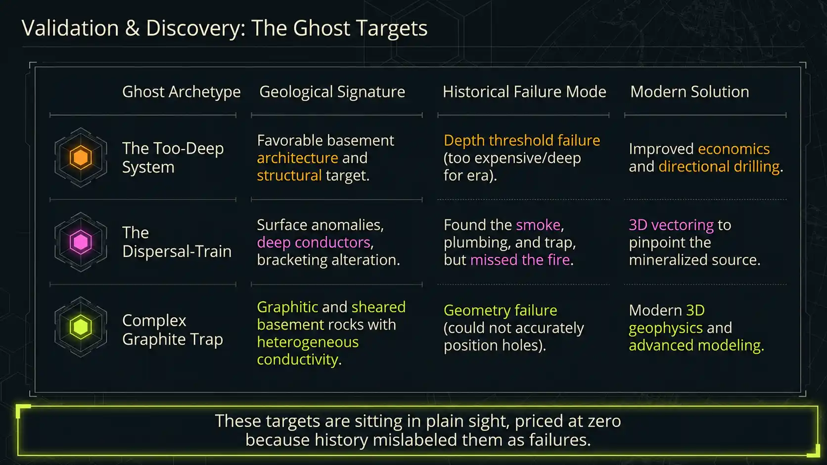
Ghost Target Type 1: The Too-Deep System
One anomaly showed the signature of favourable basement architecture and structural targeting that appears to have been downgraded because the depth was considered prohibitive under the economics and technology of the time.
In modern terms, this is not necessarily a geological failure. It may be a historical depth-threshold failure.
The question for a modern explorer is whether improved economics, deeper exploration precedent, better geophysics, and more capable drilling change the risk profile.
Ghost Target Type 2: The Dispersal-Train Near Miss
Another anomaly showed the pattern of surface or near-surface uranium evidence, broader geochemical dispersion, deeper geophysical conductors, and possible alteration signatures.
The historical work appears to have bracketed parts of the system without resolving the mineralized source.
This is a classic near-miss situation. The archive suggests that explorers may have found the smoke, the plumbing, and the trap, but not the fire.
Ghost Target Type 3: The Complex Graphite Trap
A third anomaly showed evidence of graphitic and sheared basement rocks: exactly the kind of chemical and structural environment that matters in Athabasca uranium exploration.
The historical problem appears to have been geometry. The target was complex. The conductive zone was heterogeneous. Historical geophysics and drilling may not have been able to position holes accurately enough to resolve the system.
That is not the same as saying the target failed. It may mean the historical test failed.
Modern 3D geophysics, better modelling, and directional drilling could change the interpretation.
Sitting In Plain Sight
One of the most important outcomes of this study was not that the engine found something hidden in a secret dataset.
It found a target sitting in plain sight.
The evidence was already in the archive. The reports had already been written. The geophysics had already been interpreted. The drilling had already been logged. The recommendations had already been made.
But the story had never been synthesized this way.
That is the point of Ghosts in the Machine.
Most historical failures are probably real failures. But some are not.
Some are failures of timing. Some are failures of depth. Some are failures of technology. Some are failures of commodity focus. Some are failures of corporate memory. And some are failures of synthesis.
The opportunity is to tell the difference.
Why This Matters Beyond Uranium
This case study focused on uranium in the Athabasca Basin.
But the workflow is not limited to uranium. It is not limited to Saskatchewan. It is not limited to any one deposit model, archive, or jurisdiction.
The same failure-analysis framework can be applied wherever large volumes of legacy exploration reports exist.
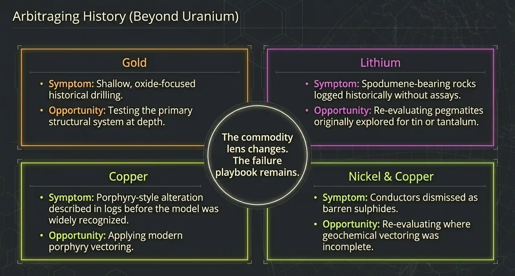
For gold, it can ask where historical drilling was shallow, oxide-focused, or structurally incomplete.
For lithium, it can search historical pegmatite reports written before lithium was the target commodity.
For copper, it can identify porphyry-style alteration or geochemical patterns described before the system was recognized as such.
For nickel and copper sulphides, it can revisit conductive targets dismissed as barren where the surrounding geochemical or geological vectoring was incomplete.
For rare earth elements, it can revisit uranium, phosphate, carbonatite, or alkaline-intrusive reports where the original commodity lens was too narrow.
The commodity lens changes. The failure playbook remains.
What This Workflow Actually Produces
It is important to be clear about what this process does and does not do.
It does not produce a drill target by magic. It does not replace geological interpretation. It does not remove the need to retrieve original reports, validate coordinates, reprocess geophysics, inspect drill logs, check land status, or build a proper 3D model.
What it does is compress the first stage of regional reasoning.
It turns millions of pages of historical text into:
- regional heat maps of unresolved exploration effort
- near-miss classifications
- mineral system fertility layers
- confluence-ranked cells
- confidential shortlists of smaller AOIs for technical deep dive
That is commercially valuable because it changes the starting point.
Instead of asking a geologist to manually read an entire regional archive, the workflow points them toward the places where historical work appears most unresolved, most system-like, and most worthy of deeper review.
It gives a team the hawk's-eye view first. Then the detailed geology begins.
From Search Tool To Discovery Engine
Most systems built around historical reports are designed to retrieve documents.
That is useful, but it is not enough.
Exploration teams do not only need to know which reports mention uranium, graphite, lithium, copper, or alteration. They need to know what those reports imply when read together.
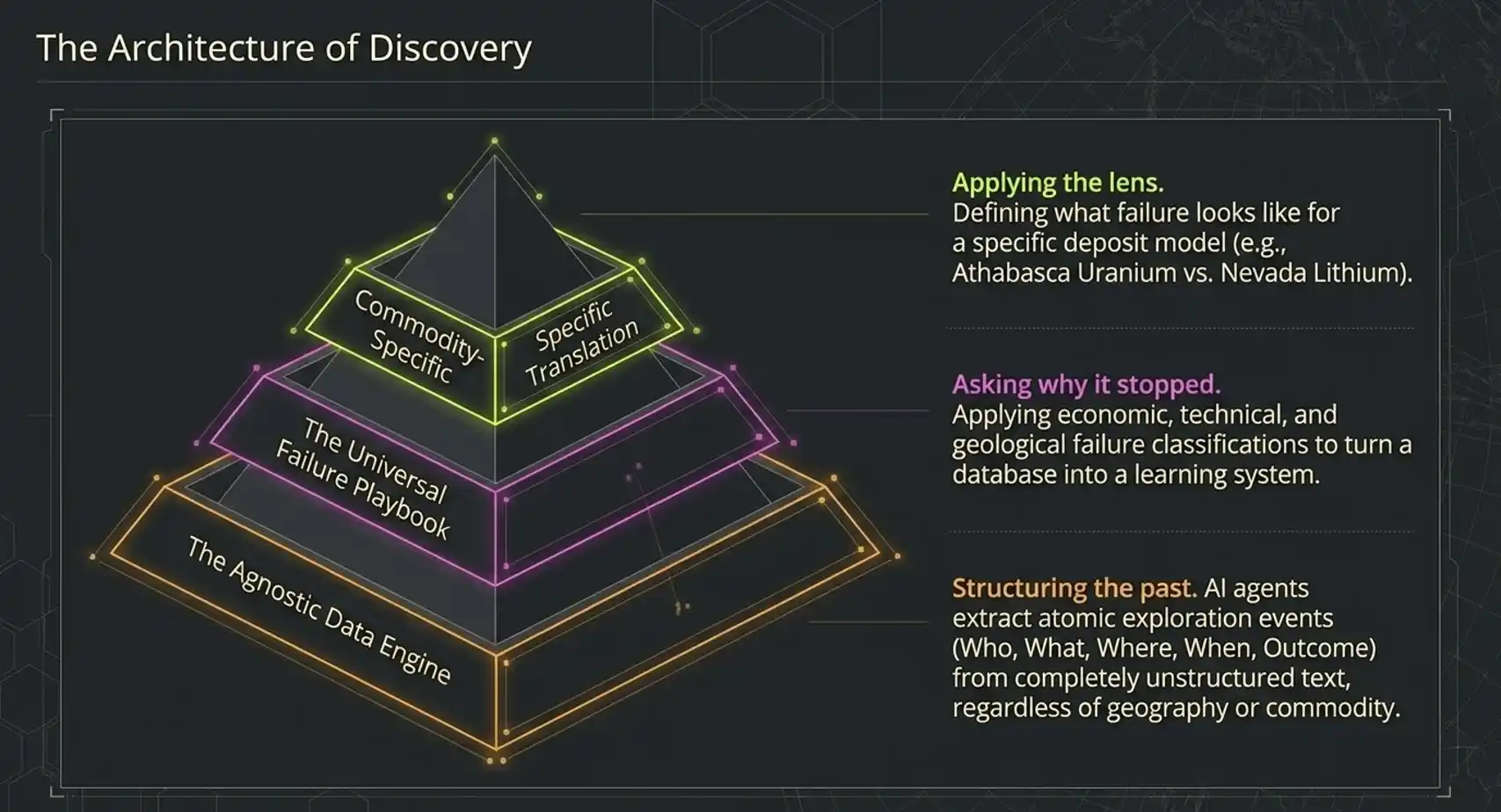
The Ghosts in the Machine workflow moves through three layers.
Layer 1: The Agnostic Data Engine
At the base layer, AI agents structure the past. They read unstructured reports and extract the atomic exploration event: who, what, where, when, and outcome.
At this layer, the system is commodity-agnostic. It does not matter whether the report is about uranium in Canada, gold in Western Australia, lithium in Nevada, copper in Saudi Arabia, or nickel in Africa. The first job is to convert legacy text into a standardized spatial-temporal record of exploration attempts.
Layer 2: The Universal Failure Playbook
Once the data is structured, the workflow asks why projects stopped.
Was it economic? Was it geological? Was it technical? Was it corporate? Was the conclusion resolved, or merely inherited?
This is the step that turns a database into a learning system.
Layer 3: Commodity-Specific Translation
Finally, the workflow applies the commodity lens.
The system asks what failure looks like for the commodity and deposit model in question. For Athabasca uranium, it looked for untested conductors, alteration halos, uranium ghost evidence, and mineral system confluence.
For another commodity, the lens changes. The principle does not.
The Real Value: Arbitraging History
The mining industry has already spent enormous amounts of money generating exploration data. Much of that capital is now sitting inside public archives, company archives, government databases, and forgotten project folders.
The data is not clean. It is not standardized. It is not easy to query. It was not written for machine learning.
And that is precisely why it still contains opportunity.
Ghosts in the Machine is a way to use the sunk cost of past exploration to guide the next round of work. Not by assuming every failure was wrong, but by systematically asking which failures deserve to be reopened.
The best opportunities are often not invisible. They are visible, but misclassified.
They are priced at zero because history labelled them as failures.
The job is to determine whether that label still holds.
Work With Us
If your team is holding a large archive of historical exploration reports, managing a regional project-generation program, evaluating a legacy portfolio, or screening a new jurisdiction, the next step is not another keyword search.
The next step is failure analysis.
We can help you answer:
- Where did historical exploration stop short?
- Which negative reports contain positive geological evidence?
- Which old targets were constrained by economics, technology, model bias, or corporate timing?
- Which areas have the same mineral-system signature as known discoveries but remain unresolved?
- Which smaller AOIs deserve a confidential technical deep dive?
Ghosts in the Machine is built for exactly that problem.
It turns old exploration archives into ranked, explainable, IP-safe target intelligence.
If you want to explore what this could look like for your region, commodity, or legacy dataset, contact RadiXplore to discuss a confidential scoping study.
Contact: contactus@radixplore.com