
Stop Guessing, Start Searching: A Practical Guide to USGS Publications for Critical Minerals
In this guide, we'll show you how to search the USGS Publications Warehouse efficiently, find geological reports relevant to mineral exploration, work around the platform's main limitations, and use modern search tools when keyword and metadata searches aren't enough.

There is a running joke in the exploration industry: the USGS Publications Warehouse contains everything you could ever want to know about North American geology, but it will fiercely defend that information from anyone trying to actually find it.
Extracting high-value data from this platform shouldn't require a degree in library sciences. This guide breaks down how to leverage the USGS Publications Warehouse efficiently, cutting through the noise so you can get back to analysing geology.
Designed for geologists, mining analysts, and junior mining investors, this guide covers:
- What the USGS Publications Warehouse is
- How to search effectively
- Platform limitations
- Alternatives
What Is the USGS Publications Warehouse?
The USGS Publications Warehouse is the official, free digital library of the U.S. Geological Survey. Serving as a centralized catalog, it houses more than 140 years of American earth-science research and scientific output.
Think of it as a highly specialized, public alternative to Google Scholar, where every indexed record is a verified USGS publication. Rather than paying commercial data providers for historic geological reports, exploration teams can use this warehouse to access foundational geological data, maps, and surveys at absolutely no cost.
For lithium and critical‑mineral work, this means you can:
- Trace how thinking about a particular deposit type or district has evolved through time.
- Find early field observations that may not be summarized in modern compilations.
- Cross‑check commodity‑supply and import‑reliance statistics against primary USGS sources.
Step-by-Step: How to Search the USGS Publications Warehouse
The USGS houses over a century of earth science data, with records dating back to the agency's founding in 1879.
The platform provides free, full-text digital downloads for internally published USGS reports and maps, as well as citations and links for USGS-authored research published in external academic journals.
Finding lithium and critical mineral data in the Publications Warehouse is straightforward once you understand a few core tools. The most effective workflow for mineral exploration is to start broad and progressively narrow your search.
Step 1: Start with the Basic Search Bar
Begin on the main homepage. Type your target term into the primary search bar to initiate a broad query. Examples include:
- Target Commodities:
lithium,critical minerals,battery metals. - Geological Targets: The name of a specific mineral, geological formation, or mining district.
Press Enter to run the search. The database will return a comprehensive mix of books, legacy maps, field reports, and data releases related to your keyword.
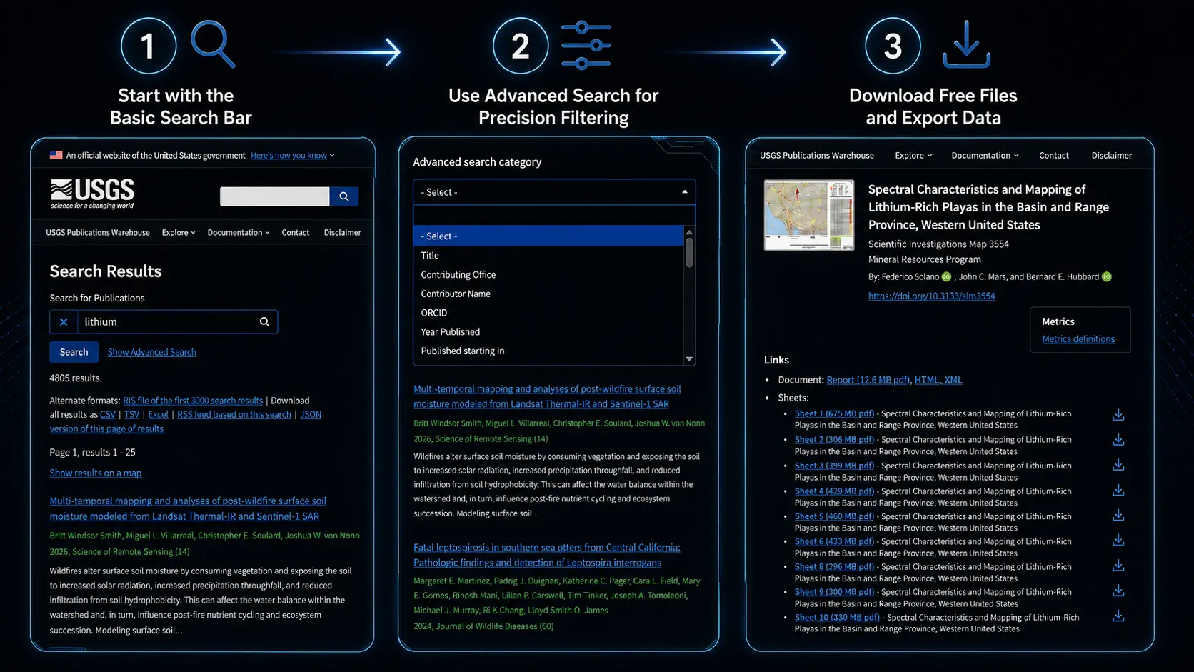
Step 2: Use Advanced Search for Precision Filtering
If your basic search yields thousands of results, click the Advanced Search or category-filter options located near the main search bar. This transforms a noisy search into a focused reading list. You can narrow the database by:
- Year Range: Filter for the last five to ten years to isolate modern critical mineral reports.
- Author Name: Track research from a specific USGS geologist or scientific team.
- Series Name: Limit results to specific publication types, such as Open-File Reports (OFRs), Professional Papers, or geological map series.
Step 3: Map Your Results (Spatial View)
For a geographic perspective, use the Show results on a map option at the top of the list (when available). This tool plots the publications on a web map, allowing you to:
- See which reports intersect your state, county, or sedimentary basin of interest.
- Quickly identify clusters of historical research around specific mining districts or structural belts.
Note: While geographic footprints in historical databases aren't always perfect (covered more in the limitations section below), the map view is an excellent way to visually screen which documents relate to your project area.
Step 4: Download Free Files and Export Data
Once you locate a high-value publication:
- Open the Record: Click the publication title to view its detail page.
- Verify Relevance: Review the abstract and metadata to confirm it fits your exploration criteria.
- Download the Data: Click the download link to obtain the full-text PDF, high-resolution map, or associated data files for free.
Limitations and Pain Points of the USGS Publications Warehouse
The USGS Publications Warehouse is a highly powerful tool for mineral exploration, but it does have a few quirks that can impact your workflow. Understanding these limitations ahead of time will save you hours of frustration.
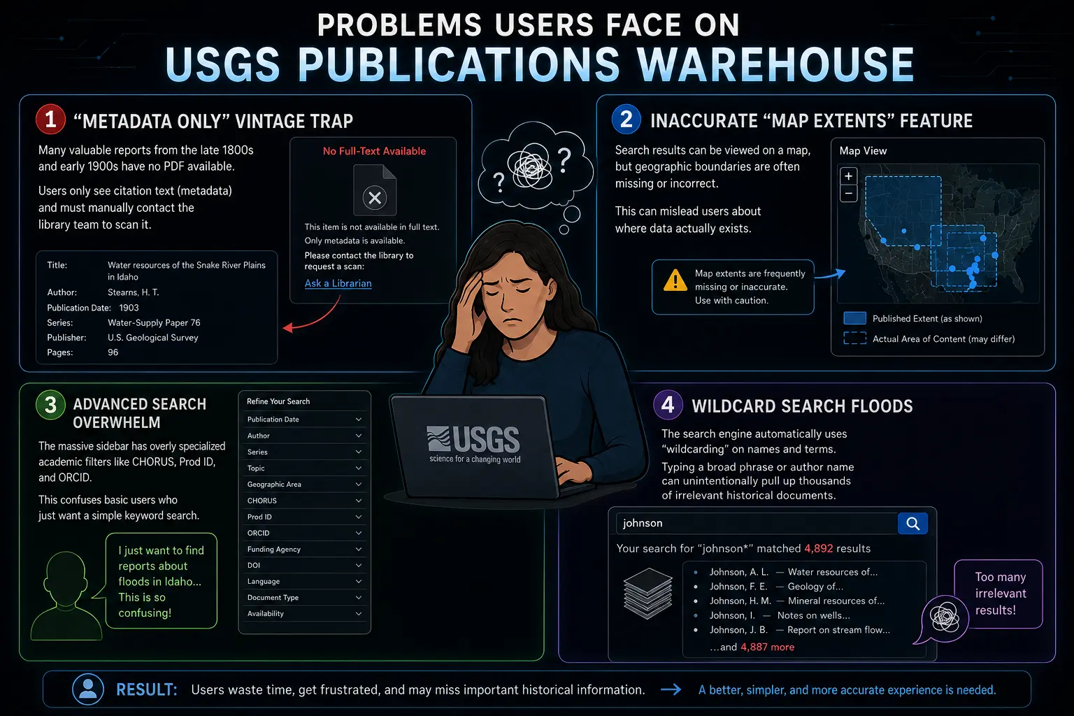
1."Metadata Only" Vintage Records
Many high-value legacy geological reports from the late 1800s and early 1900s appear in the catalog with citation information but lack a digitized PDF attachment. In these cases:
- The detail page will display the title, authors, year, and occasionally a short abstract.
- There is no direct link to a downloadable file.
2.Inaccurate or Missing Map Extents
The "Show results on a map" feature is a convenient visual aid, but the geographic boundaries tied to each publication are not always precise. The platform itself notes that:
- Many older historical records lack proper spatial metadata.
- Some newer records only feature approximate geographic footprints.
As a result, you should treat the map view as a high-level discovery tool, not a precise GIS layer. Always verify the actual coverage area by reading the abstract and checking the full text before importing data into your mapping software.
3.Overwhelming Advanced Search Options
The advanced search interface exposes numerous fields designed for librarians and power users, including inputs like CHORUS, Prod ID, or ORCID identifiers. For most exploration geologists or mining investors, this complexity can be a distraction rather than a help.
To avoid getting stuck:
- Focus exclusively on a small subset of high-yield filters: publication year, author, and series.
- Ignore the highly specialized fields unless you have a specific citation you need to track down.
4.Wildcard Search Flooding the Results
The USGS search engine utilizes wildcard logic on names and certain text fields. Because of this:
- Broad phrases or partial names can return thousands of loosely related documents.
- Simple queries, such as a common surname, can instantly swamp your results list with irrelevant data.
How Modern Tools Can Help
The USGS Publications Warehouse is excellent for discovering and downloading scientific work, but it is not designed as a modern exploration‑workflow tool. Once you move beyond a few reports, it becomes hard to search across thousands of PDFs, connect themes between publications, or quickly visualize patterns.
This is where specialized tools start to play a role: they sit on top of public repositories, read and index unstructured reports, and let you query everything with exploration‑style questions rather than just basic keywords
These reports typically are:
- Scanned PDFs with maps, handwritten notes, and assay tables
- Not included directly in USGS Warehouse
- Not easily searchable by context or combination of keywords
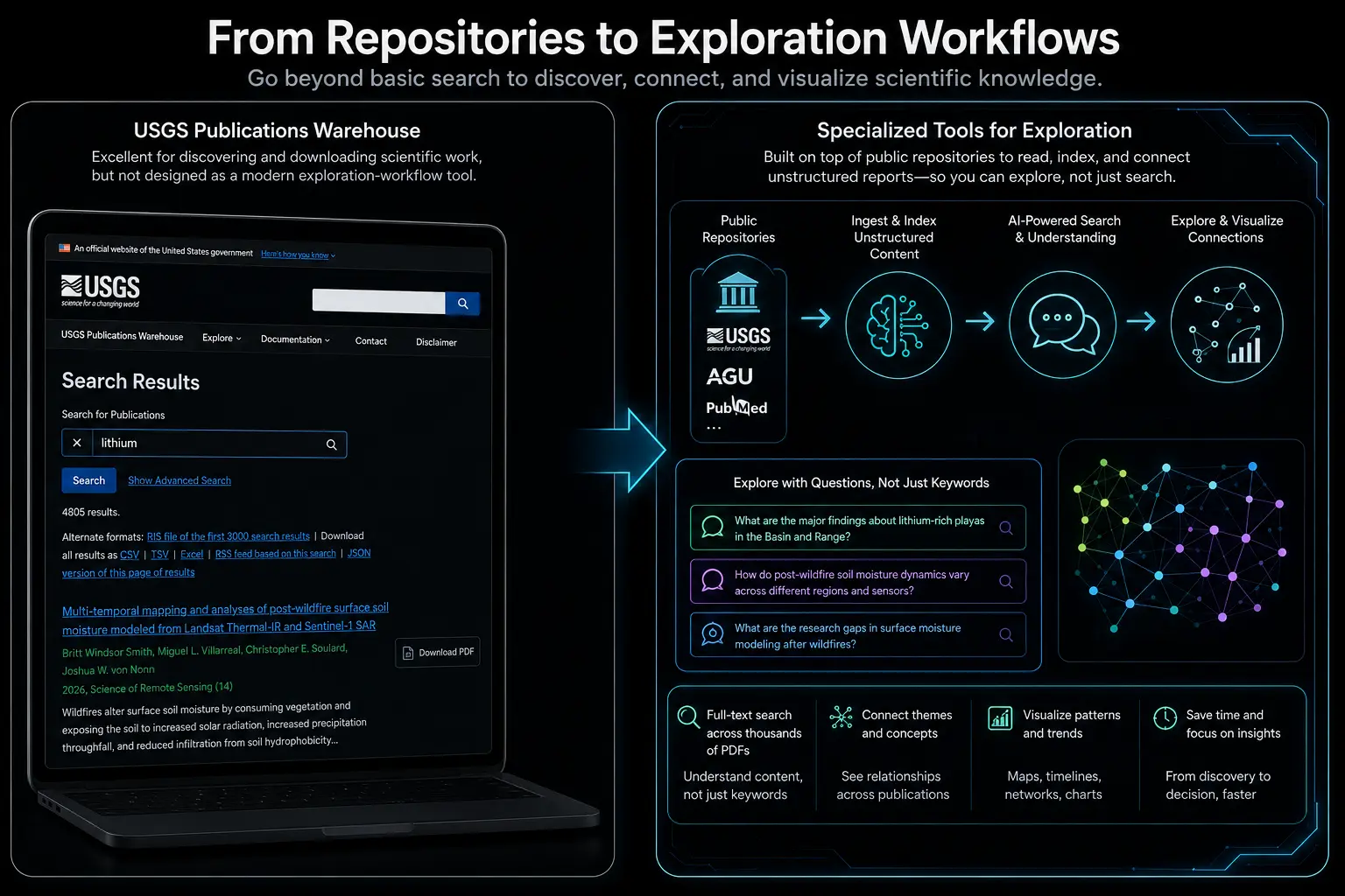
Imagine an old copper district where USGS mapped dozens of prospects and drilled core. The Publications Warehouse includes a report which has the thin‑section notes and multi‑element assays that show high cesium, rubidium, and other unusual elements in a late alteration phase. At the time, these were treated as curiosities and the area was written off as uneconomic copper. In the catalog today, that paper sits under a generic copper‑deposit title with no mention of critical minerals. To find it using the Warehouse alone, you would have to open and read several copper reports and spot those minor elements by hand.
A modern text‑and data‑mining tool can handle this very differently. It can read the tables and descriptions, flag critical‑mineral pathfinders, and link them to specific rock units and structures. A search like “alkali‑rich alteration with anomalous cesium in Proterozoic terranes” could instantly surface that old “failed copper” project as a new critical‑minerals lead. RadiXplore is one example of a tool that does this kind of geology‑aware search across large public mining datasets.
So how can you work smarter?
Modern search tools can help geologists interrogate these archives differently - using AI and natural-language processing to search concepts, relationships and geological context rather than relying only on catalogue metadata and exact keywords.
 Russell Menezes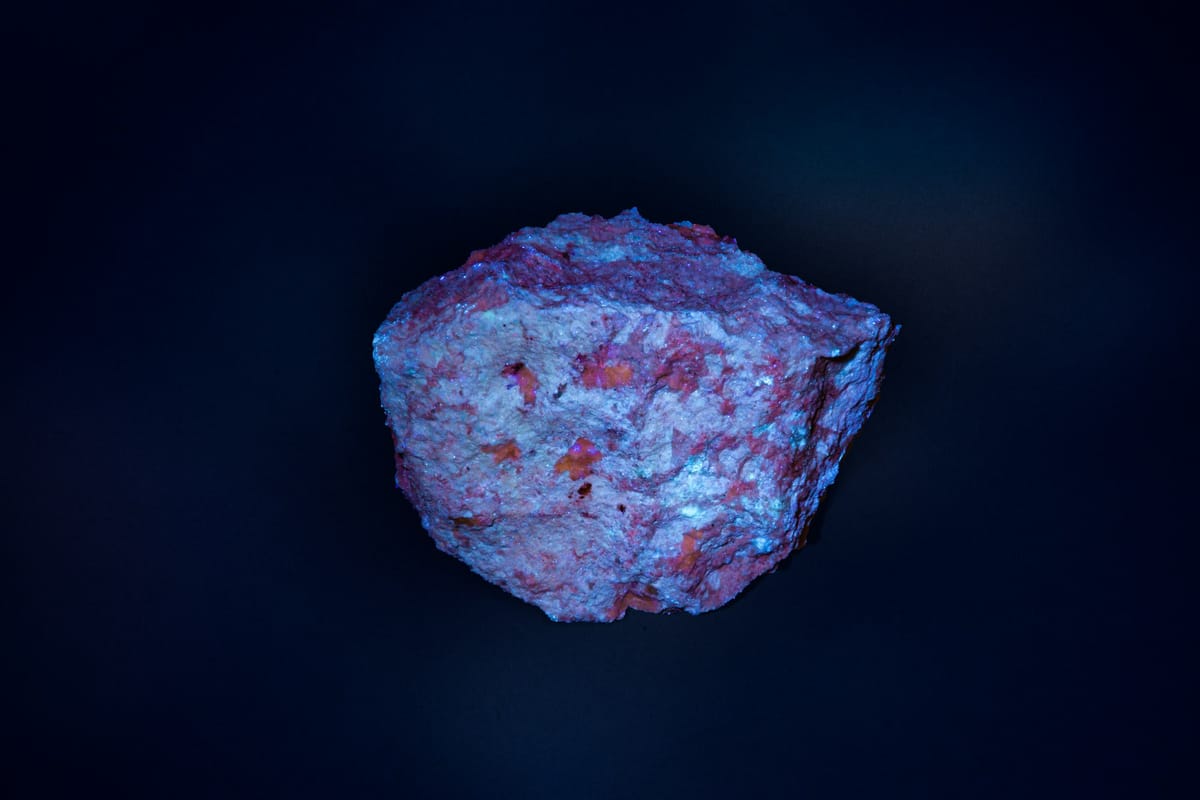
Why RadiXplore Is Easier to Use?
The biggest difference is not another search box. RadiXplore is designed around the way geologists actually investigate a problem - moving from an initial question, through evidence, context and follow-up questions, to an answer.
A geological investigation rarely starts and ends with a single keyword. One question leads to another: What was drilled nearby? What alteration was reported? Was the target ever properly tested? What did previous explorers conclude? RadiXplore is designed to let users follow that chain of questions without repeatedly downloading files, rebuilding searches, or switching between disconnected datasets.
1. Search with Geological Language
Users do not need to know the exact wording used in every historical report. For example, a geologist could search for evidence of fractionated granites associated with lithium-bearing pegmatites rather than guessing whether historical authors described the same system using terms such as pegmatite, rare-element granite, spodumene, lepidolite, or LCT.
2. Move Directly from Result to Source
Instead of downloading files, opening them one by one, and searching manually, users can move from a mapped or ranked result directly to the relevant report and source context.
3. Combine Text, Tables, Figures, and Maps
Critical minerals intelligence is distributed across different data types. RadiXplore brings these elements into one workflow rather than forcing the geologist to manage separate searches for text, images, tables, and locations.
4. Use AI Without Losing Geological Control
The platform surfaces patterns and structures information, but the source document remains available for validation. This is important because exploration decisions require interpretation, not blind acceptance of an AI output.
5. Start with a Question, Not a File Directory
Search is usually only the beginning. A relevant result may trigger questions about nearby drilling, previous exploration, alteration, geochemistry, target depth, ownership, or whether a recommendation was ever followed up.
RadiXplore is designed to help users move through those questions within the same workflow rather than treating every question as a new search exercise.
Traditional workflows often begin with:
Which folder contains the report?
RadiXplore lets users begin with:
Where is the evidence for this mineral system?
That is a much more useful starting point for exploration.
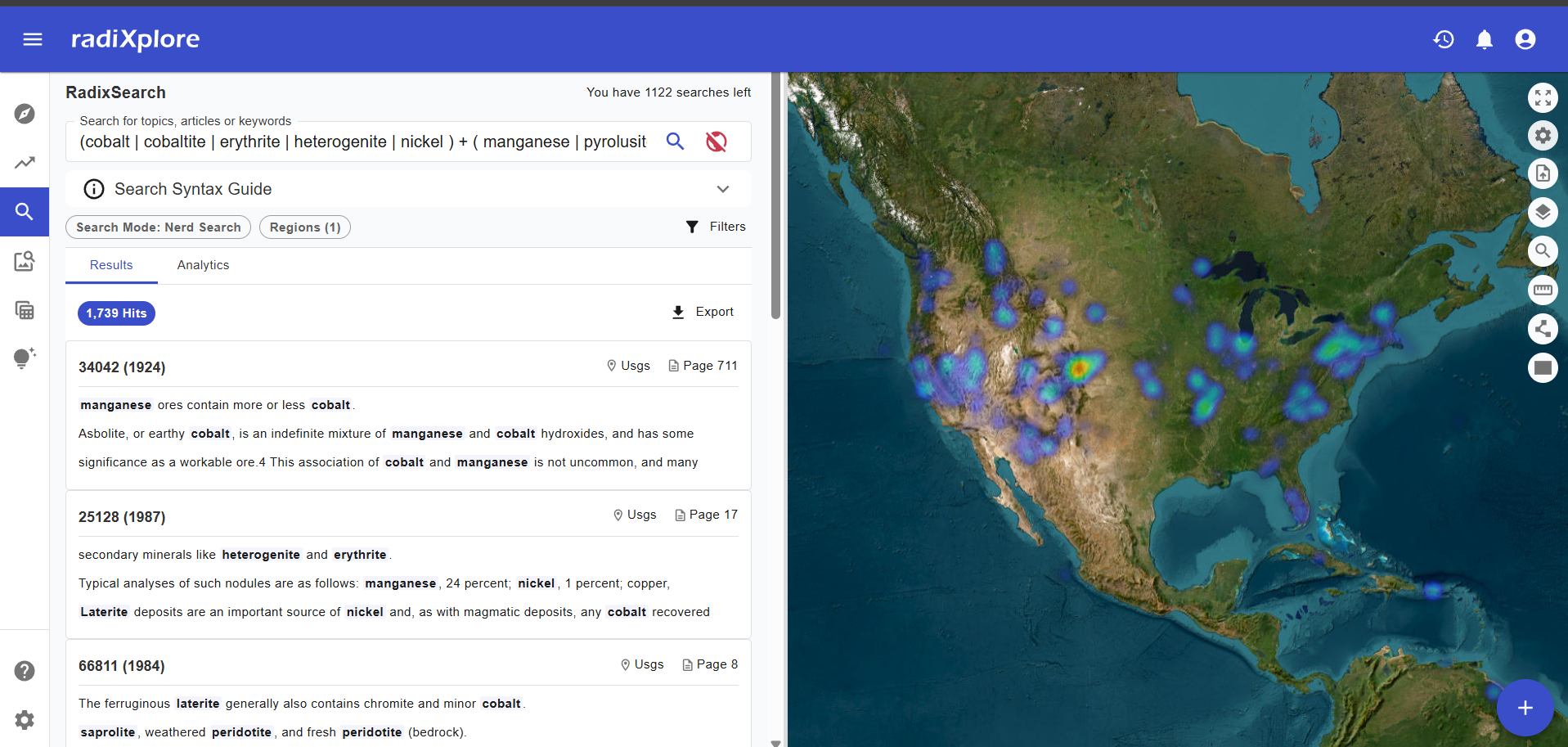
In practical terms, the difference might look like this:
Traditional USGS workflow
Search for "lithium" → filter hundreds of publications → open likely reports → search individual PDFs → inspect tables and figures → manually record locations → compare findings across reports.
RadiXplore workflow
Ask a geological question → surface relevant evidence across reports → see where it occurs spatially → inspect supporting text, tables or figures → open the original source → continue investigating related geological questions.
In this example, the search is not simply locating reports that contain a single keyword. Multiple geological terms and relationships are searched together in a geologically meaningful way, with matching passages surfaced directly alongside their locations. Users can then inspect the source material and continue refining the investigation. The NLP model also accounts for variations common in legacy documents, including spelling differences, OCR errors, and different ways the same geological terms may be represented - reducing the chance that relevant evidence is missed simply because the wording is inconsistent.
The results are also visualised spatially as a heatmap, making it easier to see where relevant evidence is concentrated and identify geographic patterns that may not be obvious from a list of search results alone. Users can then inspect individual results, return to the underlying source material and continue refining the investigation.
Closing Thoughts
The USGS Publications Warehouse is an incredibly valuable archive, but finding useful geological evidence across more than a century of reports can still require a lot of manual searching, reading and cross-checking.
RadiXplore is designed to shorten that process. By searching the underlying content of geological reports, surfacing relevant passages and connecting them to spatial context, geologists can spend less time finding information and more time deciding what it means.
The goal is not to replace geological interpretation. It is to make more of the available evidence easier to find, investigate and validate.
Frequently Asked Questions
Is the USGS Publications Warehouse free to use?
Yes. The USGS Publications Warehouse is a free public resource containing publications, reports, maps, data releases and other scientific material produced by the U.S. Geological Survey. Many publications can be downloaded directly, although some older records may contain only bibliographic information or links to external sources.
How do I search the USGS Publications Warehouse?
The simplest approach is to begin with a broad geological, commodity or location-based search and then narrow the results using filters such as publication year, author and publication series. For mineral exploration, searches can include commodities such as lithium or critical minerals, geological formations, deposit types, districts or specific geological terms.
Can I search USGS publications by location?
Yes. Where spatial information is available, USGS publications can be viewed geographically using the map view. However, the mapped extent of older publications may be incomplete or approximate, so the underlying report should still be checked before using the location as precise geological or GIS data.
Can I search inside historical USGS geological reports?
The Publications Warehouse is primarily designed to help users discover publications rather than investigate the contents of thousands of reports simultaneously. Finding specific geological relationships, observations or terminology may therefore require opening and searching individual documents.
Tools that index the underlying report content can make this process faster by allowing multiple reports to be searched together and by surfacing the passages in which relevant geological evidence occurs.
How can AI and NLP help search historical geological reports?
AI and natural-language processing can help identify geological concepts even when terminology differs between reports. This is particularly useful for legacy geological documents, where spelling, OCR errors, historical terminology and inconsistent naming can make exact keyword searches unreliable.
Platforms such as RadiXplore use these techniques to search geological relationships across large document collections, surface the supporting passages and display relevant results spatially. The original source material remains available so geologists can validate the evidence and make their own interpretation.